
Intense EF3+ Tornado Outbreak Targets Central Illinois and Western Indiana With Large Hail and Destructive Winds as Fast-Moving Storms From 4 to 9 PM
ILLINOIS/INDIANA — A full-scale tornado outbreak is unfolding today, June 17, with intense EF3+ tornadoes possible across central Illinois into western Indiana during the primary window of 4 to 9 PM. The forecast has remained on track through two days of monitoring, with explosive atmospheric ingredients still firmly in place. Wind shear strongly favoring supercells combined with fast storm speeds of 50+ mph will reduce lead time for warnings significantly, meaning residents must be sheltered before storms arrive rather than waiting for sirens.
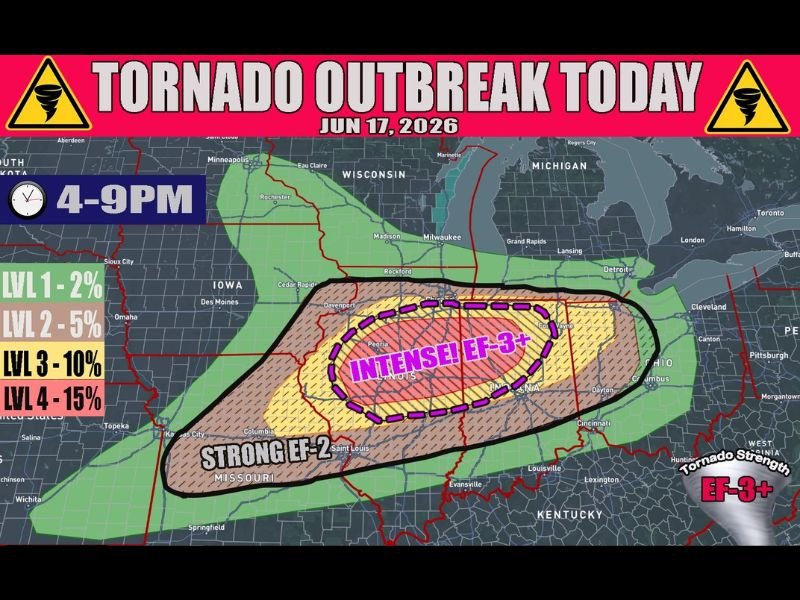
EF3+ Intense Tornado Zone Covers Central Illinois Into Western Indiana
The Level 4 tornado probability zone with 15% odds is centered directly over central Illinois and western Indiana, explicitly labeled as the EF3+ intense tornado zone on the outbreak map. This corridor carries the highest probability of violent, long-track tornadoes capable of catastrophic damage across multiple communities if they take unfortunate paths.
The Level 3 zone with 10% probability surrounds this core, covering the Quad Cities, Rockford, Chicago, and Fort Wayne corridors, while the Level 2 5% zone extends through Missouri, Kentucky, and Ohio.
Strong EF2 Tornadoes Possible Across Broader Missouri to Ohio Corridor
Outside the intense core zone, strong EF2 tornadoes remain possible across a much wider area stretching from eastern Missouri westward and into western Ohio. Cities including St. Louis, Columbus, Dayton, Louisville, and Lexington all fall within the broader tornado threat zone today.
Strong tornadoes anywhere in this zone can be life-threatening, and all tornado warnings across this entire region must be treated with immediate life-safety urgency regardless of the risk level designation.
Fast Storm Speeds Mean Less Time to React When Warnings Are Issued
With storms moving at 50+ mph, the time between a tornado warning being issued and a tornado arriving at your location could be just minutes. This is not a situation where residents can wait to hear sirens or see approaching storms before moving to shelter.
Shelter plans must be finalized and people must be in position before the 4 PM window opens today. Keep phones charged and alerts active through 9 PM.
Stay with NapervilleLocal.com for the latest weather updates and local forecast coverage.

I’ve lived in Naperville long enough to see how quickly our community changes — from new developments downtown to sudden shifts in our Midwest weather. Reporting on Naperville news and daily forecasts gives me the chance to keep neighbors informed about what really matters. My goal is simple: deliver clear, timely updates so you always know what’s happening in our city and what to expect from the skies above.