
Intense Tornadoes and 75+ MPH Winds Strike Lafayette, Kokomo, and Indianapolis Under Rare Level 4 Moderate Risk as Indiana Severe Weather Outbreak Runs Wednesday
INDIANA — A rare Level 4 of 5 Moderate Risk severe weather outbreak is expected to unfold across north-central and central Indiana this evening, with the main event beginning after 6 PM ET and storms clearing southeast Indiana by approximately 3 AM Thursday. Intense tornadoes, wind gusts of 75 mph or greater, and very large hail up to 2 inches are all on the table for the Level 4 zone. The biggest question mark remains how much the atmosphere can recover behind an Illinois storm complex arriving around noon today.
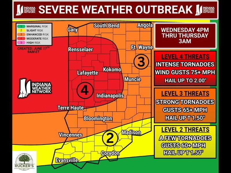
Level 4 Zone Covers Lafayette, Kokomo, Rensselaer, and Indianapolis
The Level 4 Moderate Risk zone is centered over north-central and central Indiana, covering Gary, Rensselaer, Lafayette, Kokomo, and Indianapolis. Level 4 threats include intense tornadoes, wind gusts of 75+ mph, and hail up to 2.00 inches in diameter.
A Level 3 Enhanced Risk surrounds this core, covering South Bend, Fort Wayne, Muncie, Terre Haute, and Bloomington, where strong tornadoes, gusts of 65+ mph, and hail up to 1.50 inches are expected. Southern Indiana including Vincennes, Madison, Corydon, and Evansville falls under a Level 2 Slight Risk.
Three-Stage Timing Through the Day and Evening
The first round arrives as an Illinois storm complex pushes into Indiana around noon, potentially carrying a severe weather risk though confidence remains low. Isolated severe storms could develop across central to north-central Indiana as early as 3 to 4 PM.
The main significant severe weather event begins after 6 PM, when a broken line of storms forms in Illinois and pushes southeast into Indiana. This evening round carries the greatest tornado and wind potential through the overnight hours until approximately 3 AM Thursday.
Atmosphere Recovery Behind Noon Complex Is the Critical Variable
Whether the main event reaches its full potential depends on how well the atmosphere recovers after the noon Illinois complex moves through. Cloud cover and residual rainfall could limit storm fuel or shift risk corridors southward. Regardless, forecasters anticipate a significant severe weather event this evening.
Have shelter plans locked in before 4 PM, keep alerts active through the overnight hours, and stay weather aware until 3 AM Thursday.
Stay with NapervilleLocal.com for the latest weather updates and local forecast coverage.

I’ve lived in Naperville long enough to see how quickly our community changes — from new developments downtown to sudden shifts in our Midwest weather. Reporting on Naperville news and daily forecasts gives me the chance to keep neighbors informed about what really matters. My goal is simple: deliver clear, timely updates so you always know what’s happening in our city and what to expect from the skies above.