
NHC Monitoring Old Arthur Remnants for Possible Redevelopment Off the Mid-Atlantic Coast as 10-Day Ensemble Models Show Quiet Tropical Pattern Through Late June
ATLANTIC BASIN — The National Hurricane Center is highlighting the remnants of old Arthur as a candidate for possible redevelopment, according to Thursday June 18 tropical update. The disturbance is expected to stay out to sea well off the Mid-Atlantic coastline, posing no threat to land areas. Beyond this lone area of interest, the 10-day ensemble models show little else developing across the Atlantic Basin, suggesting the tropics may remain relatively quiet heading into early July.
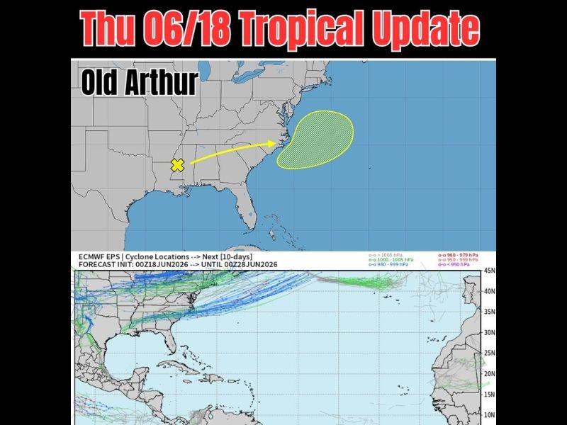
Old Arthur Remnants Being Watched Off the Mid-Atlantic Coast
The NHC graphic shows the remnant circulation of old Arthur marked with a yellow X currently positioned over the Tennessee and Georgia corridor, with a yellow arrow indicating a northeast track toward a development zone off the Carolina and Mid-Atlantic coastline. The hatched development area is positioned well offshore in the open Atlantic, east of the Carolinas and well removed from any coastal areas.
The system’s expected track keeps it offshore and away from land, meaning even if some redevelopment occurs, there is no anticipated land impact associated with this system. It will remain a feature to monitor but not a cause for concern for coastal residents at this time.
ECMWF 10-Day Ensemble Shows Quiet Pattern Through Late June
The ECMWF EPS cyclone location tracks initialized at 00Z June 18 and running through 00Z June 28 show a quiet tropical pattern across the Atlantic Basin and Gulf of Mexico through the end of the month. The ensemble tracks show the Arthur remnant feature moving northeastward and out to sea, with little other activity across the main development regions of the tropical Atlantic.
This suggests the Atlantic hurricane season may remain subdued heading into early July, with no significant tropical threats on the horizon for the Gulf Coast, Florida, or the broader U.S. coastline in the 10-day window.
No Other Areas of Concern Across the Atlantic or Gulf at This Time
With nothing else showing on the 10-day ensemble guidance beyond the offshore Arthur remnants, the tropical weather pattern appears likely to stay quiet through the transition into July.
Stay with NapervilleLocal.com for the latest weather updates and local forecast coverage.

I’ve lived in Naperville long enough to see how quickly our community changes — from new developments downtown to sudden shifts in our Midwest weather. Reporting on Naperville news and daily forecasts gives me the chance to keep neighbors informed about what really matters. My goal is simple: deliver clear, timely updates so you always know what’s happening in our city and what to expect from the skies above.