
Hot Friday With Western Slope Near 101° Gives Way to Severe Storm Risk Across Colorado’s Front Range and Eastern Plains as Damaging Winds and Hail Threaten Saturday
COLORADO — Today brings another hot stretch across Colorado and the surrounding region on this last full day of spring, with widespread 80s and 90s and the Western Slope topping out near 101°F. While today remains primarily a heat story with only isolated late-day storms south of I-76, attention is shifting to Saturday, when a passing disturbance will bring stronger winds aloft, more scattered thunderstorm development, and the potential for a few severe storms across the Plains.
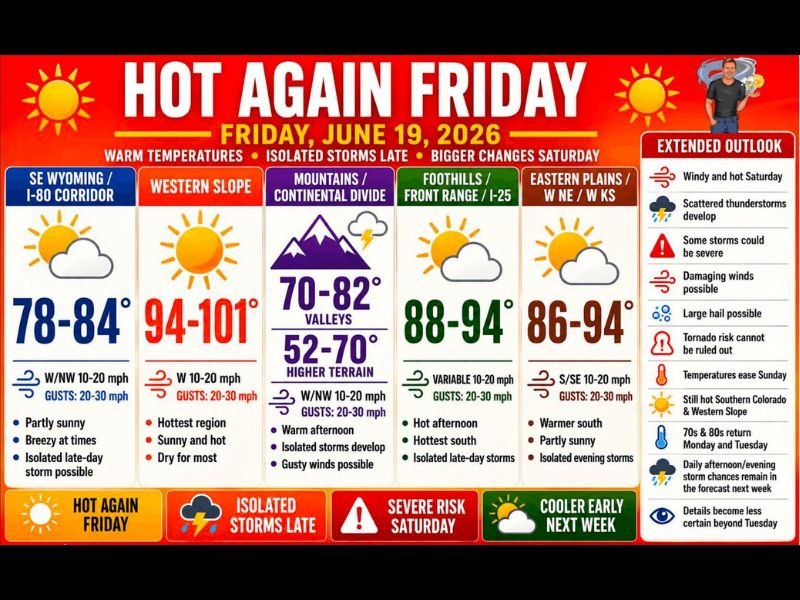
Western Slope Hottest Today at 94 to 101°F as Heat Dominates
The Western Slope remains the hottest zone today at 94 to 101°F with sunny and dry conditions for most. The Foothills, Front Range, and I-25 Corridor are forecast for 88 to 94°F with the hottest readings to the south, while the Eastern Plains, western Nebraska, and western Kansas reach 86 to 94°F with isolated evening storms possible.
SE Wyoming and the I-80 Corridor are cooler at 78 to 84°F, and Mountain Valleys range from 70 to 82°F with isolated storms developing this afternoon. Coverage of any rain today remains fairly limited, with many locations staying dry.
Severe Weather Risk Increases Saturday With Damaging Winds and Hail Possible
Saturday is the day drawing the most attention, as a passing disturbance brings stronger winds aloft and increases thunderstorm coverage. While the overall risk along the I-25 Corridor appears relatively low, the threat increases as storms move east onto the Plains.
Main concerns for Saturday include damaging winds, large hail, and an isolated tornado that cannot be ruled out. The exact placement of boundaries and storm development will determine who sees the strongest activity.
Relief Arrives Sunday With Cooler Temperatures Returning Early Next Week
Temperatures begin easing Sunday, though southern Colorado, Kansas, and the Western Slope stay fairly hot. By Monday and Tuesday, many locations return to the 70s and 80s with daily afternoon and evening storm chances returning to the forecast as the pattern becomes more active next week.
Stay with NapervilleLocal.com for the latest weather updates and local forecast coverage.

I’ve lived in Naperville long enough to see how quickly our community changes — from new developments downtown to sudden shifts in our Midwest weather. Reporting on Naperville news and daily forecasts gives me the chance to keep neighbors informed about what really matters. My goal is simple: deliver clear, timely updates so you always know what’s happening in our city and what to expect from the skies above.