
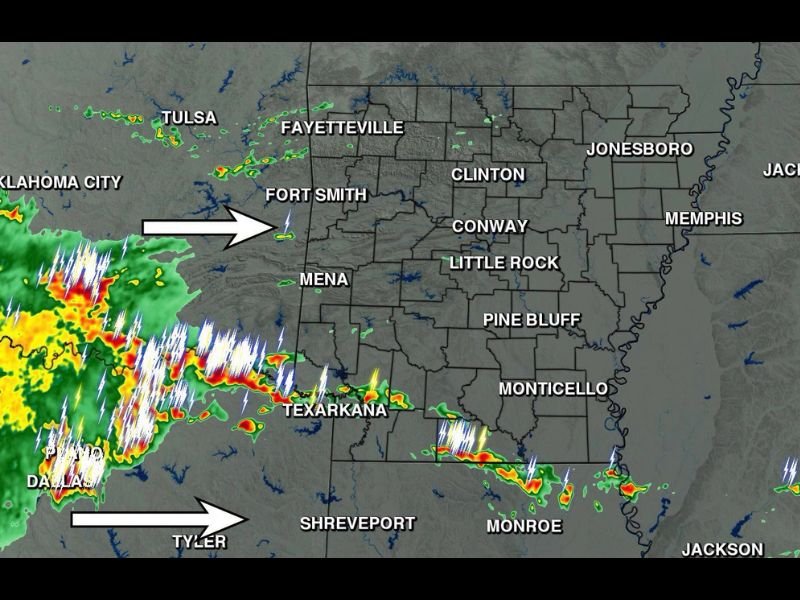
Large Storm Complex Heads Into Southern Arkansas Including Texarkana and Monticello With Rain and Thunder This Afternoon as Severe Risk Stays Low
ARKANSAS — A large complex of storms is being tracked this morning moving toward Arkansas from the west, with the system expected to mostly impact the southern half of the state through this afternoon. Plenty of rain and thunder are on the way, though the overall severe weather risk today remains pretty low. The storm complex is currently tracking across eastern Oklahoma and northeast Texas, pushing toward the Arkansas border.
Southern Arkansas Including Texarkana Faces the Main Impact Zone
The radar shows an extensive line of storms stretching from near Fort Smith southward through Texarkana and into the Shreveport and Monroe area of Louisiana. This activity is tracking eastward and is expected to spread across the southern half of Arkansas through the afternoon hours.
Texarkana, Mena, and the broader southwest Arkansas corridor will likely see the storms first as the complex continues its eastward push, with Monticello and points east potentially seeing activity later in the day as the system progresses.
Plenty of Rain and Thunder Expected With Low Severe Risk
While the storm complex is large in coverage, forecasters are emphasizing that the severe weather risk associated with this system today is low. Residents across southern Arkansas should expect periods of rain and thunder rather than a significant severe weather threat.
This is a beneficial rain-producing system for the region rather than a dangerous severe weather setup, though lightning safety should still be observed whenever thunderstorms are in the immediate area.
Northern Arkansas Including Fayetteville and Jonesboro Likely Spared
Areas across northern Arkansas, including Fayetteville, Clinton, Jonesboro, and Jackson, are not expected to see significant impacts from this storm complex, as the system’s primary track favors the southern half of the state. Little Rock and Conway sit in a transition zone that could see some activity depending on how far north the complex tracks through the day.
Forecasters will continue monitoring the complex throughout the morning and afternoon as it moves into Arkansas.
Stay with NapervilleLocal.com for the latest weather updates and local forecast coverage.

I’ve lived in Naperville long enough to see how quickly our community changes — from new developments downtown to sudden shifts in our Midwest weather. Reporting on Naperville news and daily forecasts gives me the chance to keep neighbors informed about what really matters. My goal is simple: deliver clear, timely updates so you always know what’s happening in our city and what to expect from the skies above.