
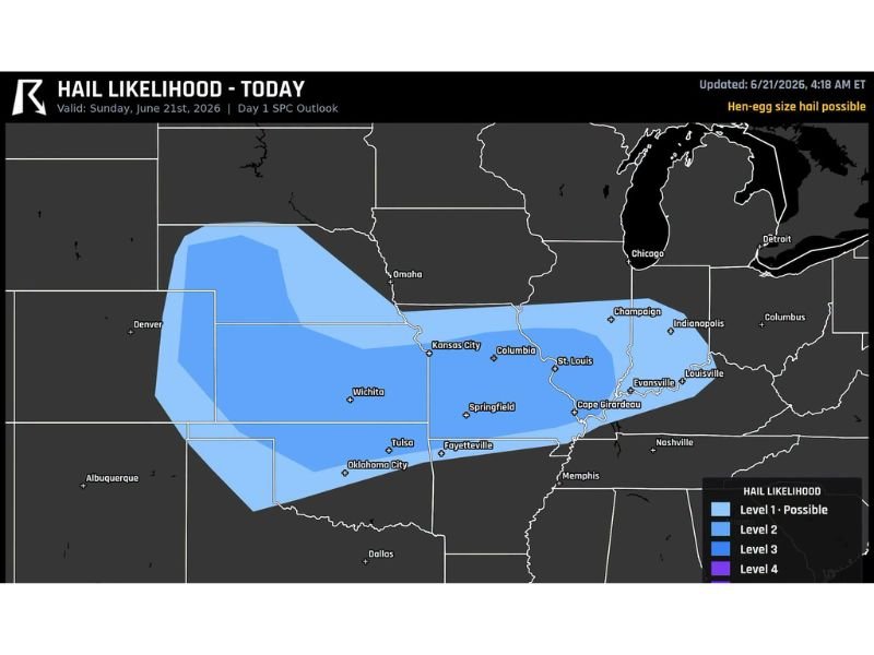
Hen Egg Size Hail Two Inches and Larger Threatens Wichita Springfield and Enid Today as Lone Storms Fire Along Front This Afternoon
WICHITA, KANSAS — Giant hail measuring two inches or larger, described as hen-egg size, is the main severe weather threat today across a broad stretch of the central United States. The highest likelihood for the largest stones centers on Wichita, Kansas, Springfield, Missouri, and Enid, Oklahoma, where isolated storms are expected to fire along a frontal boundary this afternoon.
Hail of this size is capable of denting vehicles and cracking windshields within seconds of impact. Residents in the threat area are urged to move cars under cover before storms develop.
Wichita Springfield and Enid Face Greatest Hail Risk
The Storm Prediction Center’s Day 1 outlook highlights Wichita, Springfield, and Enid as the most likely locations for the largest hailstones, with isolated supercells expected to produce the most damaging stones as they develop along the front during peak afternoon heating.
Hail Threat Stretches From the Plains Into the Ohio Valley
A Level 1 hail likelihood extends across a wide corridor from eastern Colorado and Nebraska through Kansas City, Columbia, St. Louis, and into Indianapolis, Louisville, and Champaign. While the most extreme hail is expected nearer the Wichita to Enid corridor, large hail remains possible throughout this broader zone.
Lone Storms Expected to Produce the Biggest Stones
Forecasters note that isolated, or lone, storms firing along the front this afternoon will be the primary producers of the largest hail. These discrete cells tend to maintain stronger updrafts capable of suspending and growing hailstones to two inches or greater before they fall.
Protect Vehicles Before Storms Develop
With hail of this size capable of causing significant vehicle damage, residents across the threat area, particularly near Wichita, Springfield, and Enid, are advised to move any outdoor vehicles into a garage or covered area well before storms begin to develop this afternoon.
Stay with NapervilleLocal.com for the latest weather updates and local forecast coverage.

I’ve lived in Naperville long enough to see how quickly our community changes — from new developments downtown to sudden shifts in our Midwest weather. Reporting on Naperville news and daily forecasts gives me the chance to keep neighbors informed about what really matters. My goal is simple: deliver clear, timely updates so you always know what’s happening in our city and what to expect from the skies above.