
Line of Storms Moves East Across Oklahoma Threatening Stillwater Bartlesville and Ponca City With 50 MPH Wind Gusts and Heavy Downpours
STILLWATER, OKLAHOMA — A line of storms is moving east across north-central Oklahoma this morning, with meteorologists closely monitoring its southern edge as it continues to extend and intensify. As of 8:22 a.m., the storms remained below severe limits, but wind gusts up to 50 mph and heavy downpours remain possible as the line progresses.
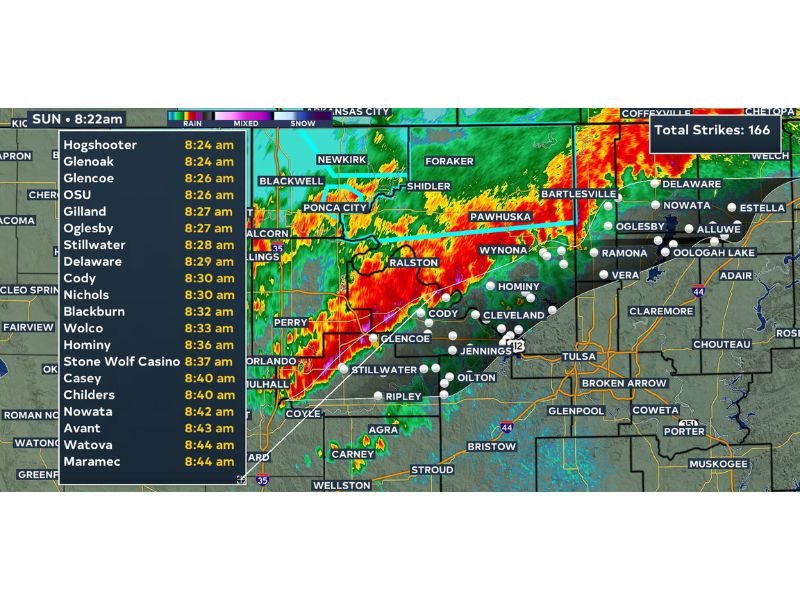
Radar shows intense reflectivity stretching from near Ponca City through Pawhuska and toward Bartlesville. Lightning activity has been significant, with 166 total strikes already recorded with the system.
Storm Line Tracks Through Ponca City and Pawhuska
The most intense portion of the storm line is currently centered over Ralston, Pawhuska, and Wynona, with the heaviest reflectivity readings shown in red and orange on radar. The system continues to extend along its southern flank, expanding the area of potential impact as it tracks eastward.
Communities From Stillwater to Bartlesville in the Path
Storm timing estimates show the line reaching Glenoak and Glencoe by 8:24 to 8:26 a.m., followed by Stillwater, Oglesby, and Gilland shortly after. The system is projected to continue toward Cody, Nichols, Blackburn, and Bartlesville through the mid-morning hours, with Hominy and Nowata expected by mid-morning as well.
Wind Gusts and Downpours Remain Primary Concerns
While the storms have not yet reached severe criteria, forecasters say the potential for wind gusts reaching 50 mph along with locally heavy rainfall remains a concern as the line continues to organize and move east through the listed communities.
Frequent Lightning Accompanies Storm Line
The system has already produced 166 lightning strikes, reflecting an active and electrically charged storm line. Residents in the path are encouraged to stay weather aware as the line progresses through the late morning hours across north-central Oklahoma.
Stay with NapervilleLocal.com for the latest weather updates and local forecast coverage.

I’ve lived in Naperville long enough to see how quickly our community changes — from new developments downtown to sudden shifts in our Midwest weather. Reporting on Naperville news and daily forecasts gives me the chance to keep neighbors informed about what really matters. My goal is simple: deliver clear, timely updates so you always know what’s happening in our city and what to expect from the skies above.