
Strong to Severe Storms Bring Damaging Winds and Heavy Rain to Western and Central North Carolina Including Asheville Winston-Salem and Charlotte After 2 PM Monday
NORTH CAROLINA — A hot and humid Monday is setting the stage for scattered showers and thunderstorms across North Carolina this afternoon and evening, driven by an approaching shortwave and frontal system. Storms are expected to develop first across Western NC before spreading into parts of Central and Eastern NC through the late evening hours.
Timing for the greatest storm activity is after 2 to 3 p.m., with coverage reaching 30 to 40 percent across the western and central portions of the state. A few storms could reach strong to severe levels, with damaging winds as the primary threat.
Damaging Winds Primary Threat With Isolated Hail Possible
The main hazard with any stronger storms today will be damaging winds, with locally heavy rainfall accompanying the most intense cells. An isolated stronger storm could also produce some hail, though hail is not expected to be a widespread concern. Forecasters note that even in areas with the highest storm coverage, not every location will see activity.
Western NC Sees Greatest Coverage Before Storms Push East
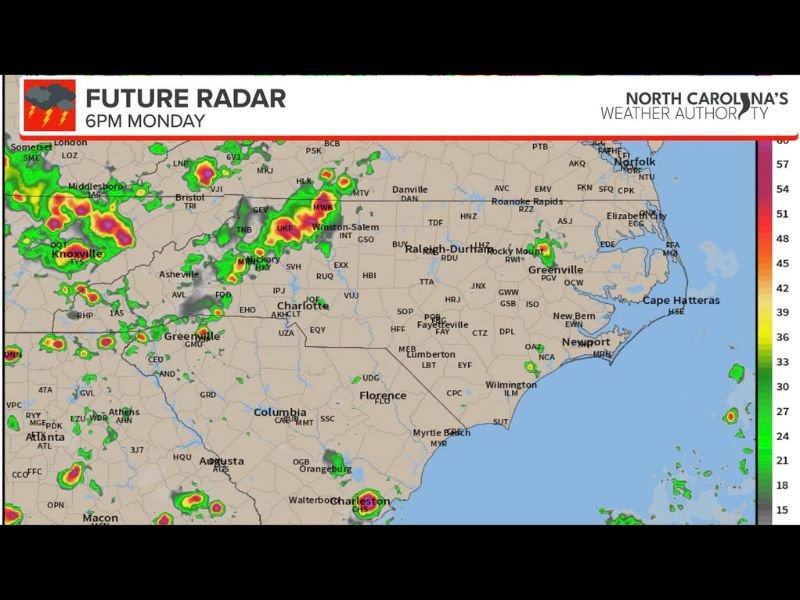
Storm initiation is expected first across Western NC, including areas near Asheville, Hickory, and Winston-Salem, before activity pushes east into the Piedmont and toward Raleigh-Durham, Charlotte, and Fayetteville through the evening hours. Future radar data suggests the heaviest cells could be focused near the western mountains and foothills during the early evening.
Coverage Remains Scattered and Hit or Miss
Despite an active afternoon setup, storm coverage is expected to remain scattered, with only 30 to 40 percent of the region seeing measurable rainfall. Forecasters caution that future radar guidance may be overdoing coverage slightly, meaning some areas could see less activity than models currently suggest.
Hot and Humid Conditions Fuel Afternoon Development
Temperatures across North Carolina are running hot and humid heading into the afternoon, providing the instability needed for storm development. Residents across Western and Central NC are encouraged to stay weather aware after 2 p.m. and monitor updates as conditions evolve through the evening.
Stay with NapervilleLocal.com for the latest weather updates and local forecast coverage.

I’ve lived in Naperville long enough to see how quickly our community changes — from new developments downtown to sudden shifts in our Midwest weather. Reporting on Naperville news and daily forecasts gives me the chance to keep neighbors informed about what really matters. My goal is simple: deliver clear, timely updates so you always know what’s happening in our city and what to expect from the skies above.