
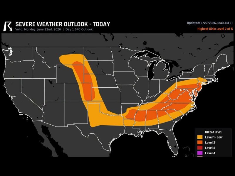
Level 2 Severe Weather Outlook Targets Northeast Colorado and Virginia North Carolina Today With Large Hail Damaging Winds and Quick Tornadoes Possible
VIRGINIA — A Level 2 of 5 severe weather outlook is in effect today across two distinct and very different storm setups, covering northeast Colorado on one end and Virginia and North Carolina on the other. The SPC Day 1 outlook, updated at 8:43 a.m. ET, highlights both corridors under the same risk level but with different primary hazards driving each threat.
Storms are expected to develop this afternoon across both regions, with the overall pattern keeping the highest risk focused on the eastern setup from Virginia through the Carolinas. A Level 1 low risk surrounds both zones, extending the broader threat corridor across a wide area.
Northeast Colorado Fires Up Large Hail and Tornado Risk
Across the High Plains of northeast Colorado, storms are expected to fire off the high ground on their own this afternoon, producing very large hail as the dominant hazard. A tornado or two cannot be ruled out with these High Plains supercells, adding to the multi-hazard concern for the region during peak afternoon heating hours.
Virginia and North Carolina Face Damaging Wind Threat
The larger and more expansive Level 2 risk area stretches across Virginia and North Carolina, where storms rolling off the mountains this afternoon will push toward the coast with damaging winds as the primary concern. This corridor covers a broad swath of both states and represents the most widespread area under elevated risk today.
Quick Tornadoes Possible Near DC and Baltimore Warm Front
Near the warm front draped across the Washington DC and Baltimore area, a couple of quick tornadoes remain possible today. Forecasters flagged this zone previously as a concern, and that threat has carried forward into today’s updated outlook, keeping the mid-Atlantic region weather aware through the afternoon.
Two Separate Setups Drive Today’s Dual Risk Areas
Today’s severe weather pattern is notable for its dual nature, with the Colorado High Plains and the Virginia to Carolina corridor operating as two independent storm environments under the same Level 2 umbrella. Residents in both zones should remain alert throughout the afternoon and evening.
Stay with NapervilleLocal.com for the latest weather updates and local forecast coverage.

I’ve lived in Naperville long enough to see how quickly our community changes — from new developments downtown to sudden shifts in our Midwest weather. Reporting on Naperville news and daily forecasts gives me the chance to keep neighbors informed about what really matters. My goal is simple: deliver clear, timely updates so you always know what’s happening in our city and what to expect from the skies above.