
Below Average Temperatures Lock In Across Michigan and the Great Lakes Through End of June With Highs Staying in the 60s and 70s Before Warmup Around July 1
MICHIGAN — Summer remains on hold across Michigan and the broader Great Lakes region, with below-average temperatures expected to persist through the end of June. Forecast guidance shows highs holding in the 60s and low 70s for the remainder of the month, well below what is typical for late June across the region.
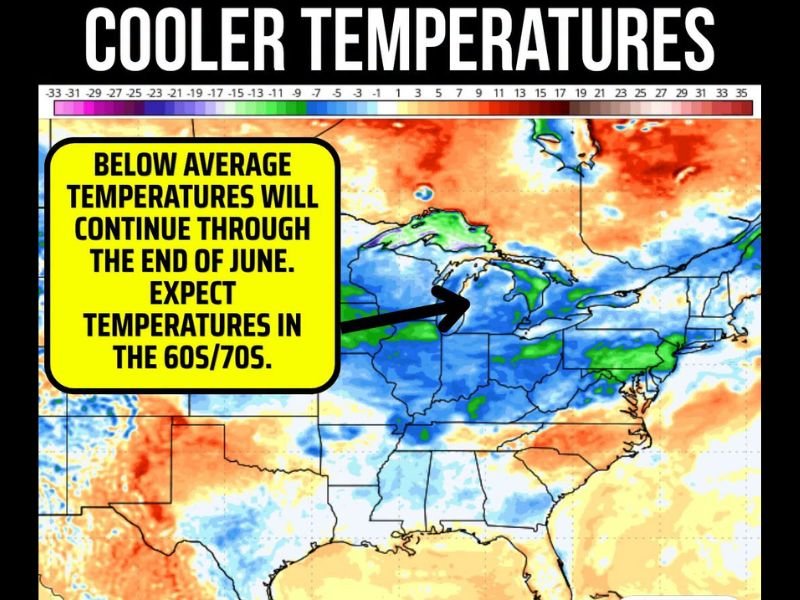
Temperature anomaly maps show a broad area of blue and green shading covering the Midwest and Great Lakes, indicating readings running significantly below historical averages. A warming trend is noted around July 1, which could signal a return to more summer-like conditions heading into the holiday weekend.
Below Average Temperatures Locked In Through Late June
The temperature pattern across Michigan and the surrounding Great Lakes states shows persistent below-normal readings with no meaningful warmup in sight until the very end of the month. Highs in the 60s and low 70s are expected to dominate the region through the final week of June, keeping summer heat at bay.
Broad Cool Pool Covers the Midwest and Great Lakes
Temperature anomaly guidance depicts a large area of below-average readings stretching across the Great Lakes, Midwest, and into portions of the Northeast. The coolest anomalies are centered over the Upper Midwest and Great Lakes region, where departures from normal are most pronounced through the end of the month.
Warming Trend Expected Around July 1
There is some good news on the horizon for those waiting on summer warmth. Forecast models are indicating a warming trend developing around July 1, which could bring temperatures back into more seasonally appropriate territory as the region heads into the Independence Day holiday weekend.
Southwest and South Running Well Above Average
In stark contrast to the cool Great Lakes pattern, temperature anomaly maps show large areas of well-above-average readings across the Southwest, Texas, and the southern United States. This sharp temperature contrast between the cool north and hot south is helping to drive the active severe weather pattern seen across the country.
Stay with NapervilleLocal.com for the latest weather updates and local forecast coverage.

I’ve lived in Naperville long enough to see how quickly our community changes — from new developments downtown to sudden shifts in our Midwest weather. Reporting on Naperville news and daily forecasts gives me the chance to keep neighbors informed about what really matters. My goal is simple: deliver clear, timely updates so you always know what’s happening in our city and what to expect from the skies above.