
Five-Day Severe Weather Outbreak Threatening Plains and Midwest April 23-27 With Strong Tornadoes, Baseball-Size Hail, and 75 MPH Winds From Iowa to Alabama
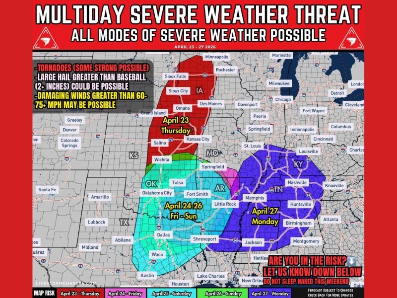
SOUTHERN PLAINS AND MIDWEST — A significant multiday severe weather outbreak is taking shape across the Southern Plains and Midwest from Thursday April 23 through Monday April 27, with all modes of severe weather possible across different regions on each day of the five-day period.
Strong tornadoes, large hail greater than 2 inches, and damaging winds exceeding 60 to 75 MPH are all explicitly highlighted as potential hazards across a threat corridor stretching from Iowa and Nebraska southward through Oklahoma, Texas, Arkansas, and eventually shifting into Tennessee, Kentucky, and Alabama by Monday.
Thursday April 23 — Iowa and Nebraska Face the Opening Round
Thursday’s threat develops along a cold front and dryline from Nebraska into Iowa, with initial supercells possible before storms transition into organized segments. A few tornadoes are possible early in the event, with large to very large hail and damaging winds becoming the dominant hazards as storms evolve through the day. The risk zone on Thursday is centered across Iowa, Nebraska, and Kansas with the threat extending northward toward Sioux Falls and Minneapolis.
Friday Through Sunday — Southern Plains Face Repeated Rounds
The threat shifts southward for the Friday through Sunday period, with the risk zone covering Oklahoma, Texas, Arkansas, and surrounding areas across the Southern Plains. A moist and unstable air mass will remain locked in place with multiple disturbances moving through the flow, supporting repeated rounds of thunderstorms across the region through the three-day window.
Sunday is flagged as potentially the most significant day of the entire stretch, particularly across Oklahoma. Increasing moisture, stronger instability, and more favorable wind fields may support a more organized severe weather setup with all hazards in play. The exact storm development location will depend heavily on prior convection and boundary positioning through the weekend.
Monday April 27 — Threat Shifts Into Tennessee, Kentucky, and Alabama
By Monday April 27 the severe weather potential shifts east into the lower Mississippi Valley, with the risk zone now centered across Tennessee, Kentucky, Alabama, Memphis, Nashville, Huntsville, Birmingham, and surrounding communities. All severe hazards remain possible on Monday, though uncertainty increases due to prior convection and evolving atmospheric boundaries left behind by the weekend storms.
Birmingham and northern Alabama fall squarely within the Monday risk zone, consistent with earlier outlooks that flagged the area in a 15 to 29% severe weather probability zone for that day.
Stay Weather Aware Through the Entire Five-Day Period
With five consecutive days of severe weather potential across a large geographic footprint, residents across Iowa, Nebraska, Kansas, Oklahoma, Texas, Arkansas, Tennessee, Kentucky, and Alabama should treat this as an extended preparedness situation. Monitor daily forecast updates closely, ensure weather alert systems are active, and have shelter plans ready before each individual day’s threat window opens throughout the April 23 to 27 period. Stay with NapervilleLocal.com for the latest weather updates and local forecast coverage.

I’ve lived in Naperville long enough to see how quickly our community changes — from new developments downtown to sudden shifts in our Midwest weather. Reporting on Naperville news and daily forecasts gives me the chance to keep neighbors informed about what really matters. My goal is simple: deliver clear, timely updates so you always know what’s happening in our city and what to expect from the skies above.