
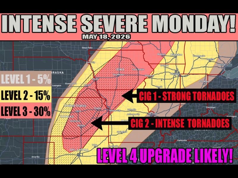
Intense Tornado Outbreak With EF3 Plus Tornadoes Hail Over 3 Inches and 75mph Winds Targeting Kansas Nebraska Iowa and Wisconsin With Level 4 Upgrade Likely Monday May 18
CENTRAL PLAINS — An intense severe weather and tornado outbreak is on track for Monday, May 18, 2026, with confidence now high enough to introduce CIG 2 intense tornado probabilities across central Kansas into southern Nebraska. EF-3 or stronger tornadoes, hail exceeding 3 inches, and winds over 75 mph are all possible across the highest risk corridor, with a Level 4 upgrade considered likely as forecast confidence continues to build. The severe weather threat extends from Wisconsin through Iowa into northwest Texas with all hazard modes possible across the full outlined zone.
CIG 2 Intense Tornado Probabilities Introduced for Central Kansas Into Southern Nebraska
The introduction of CIG 2 intense tornado probabilities across central Kansas and southern Nebraska marks a significant escalation in Monday’s threat level. This designation specifically highlights the potential for EF-3 or stronger tornadoes — long-track, violent storms capable of causing catastrophic and life-threatening damage across any community in their path.
Communities from Wichita and Salina northward through Omaha and Lincoln sit inside the most dangerous corridor on Monday’s outlook and should treat this event with the highest level of seriousness.
Level 3 at 30 Percent Covers Kansas Into Iowa With Level 4 Upgrade Likely
The current Level 3 risk at 30 percent severe probability covers a large swath from Kansas northward through Iowa, with the CIG 1 strong tornado zone extending into Iowa, Illinois, and the Chicago corridor. Forecasters are indicating that a Level 4 Moderate Risk upgrade is likely once finer details from Sunday’s storm activity become clearer.
A Level 4 upgrade would place Monday among the most significant severe weather events of the year for the central United States, covering millions of people across multiple states.
Severe Weather Extends From Wisconsin Through Iowa Kansas and Into Northwest Texas
While the Kansas and Nebraska corridor carries the most intense threat, the severe weather footprint on Monday is enormous, stretching from Wisconsin southward through Iowa, Missouri, Kansas, Oklahoma, and into northwest Texas. All modes of severe weather are possible across this entire corridor to varying degrees, meaning no community within the outlined zone should treat Monday as a routine weather day.
Residents across every state in the risk zone should confirm shelter locations, activate weather alerts, and make flexible plans for Monday well before the event arrives. Stay with NapervilleLocal.com for the latest weather updates and local forecast coverage.

I’ve lived in Naperville long enough to see how quickly our community changes — from new developments downtown to sudden shifts in our Midwest weather. Reporting on Naperville news and daily forecasts gives me the chance to keep neighbors informed about what really matters. My goal is simple: deliver clear, timely updates so you always know what’s happening in our city and what to expect from the skies above.