
Large Hail, Damaging Winds, and Tornado Risk Targeting East Texas Including Paris, Tyler, and Texarkana Friday 5-11 PM After SPC Issues Enhanced Risk Upgrade
EAST TEXAS — The Storm Prediction Center has upgraded parts of East and Northeast Texas to an Enhanced Risk for severe weather later today Friday April 25, 2026, as storms are expected to develop across Southeast Oklahoma this afternoon before growing into a larger mesoscale convective complex and pushing south into East Texas during the evening hours.
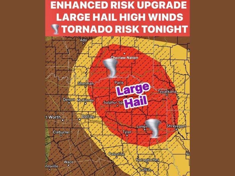
The primary threat window for East Texas runs from 5 PM through 11 PM, with large hail, damaging straight-line winds, and a tornado or two all possible as the organized storm complex moves through the region.
Enhanced Risk Core Covers Paris, Sulphur Springs, and Texarkana
The Enhanced Risk upgrade places the core severe weather zone across a broad swath of East and Northeast Texas including Paris, Sulphur Springs, Texarkana, Longview, Tyler, and surrounding communities. The red core zone on the risk map indicates the highest concentration of large hail and tornado potential, with tornado icons visible across both the northern and southern portions of the Enhanced Risk area.
A broader Slight Risk zone extends outward to cover Sherman, McKinney, Dallas, and communities further west, while the outer Marginal Risk reaches toward the Dallas and Fort Worth suburbs and surrounding areas across North Texas.
Storms Develop in Southeast Oklahoma Before Pushing Into East Texas
The storm evolution for today begins across Southeast Oklahoma this afternoon where initial storm development is expected during the early to mid afternoon hours. These storms will then grow upscale and organize into a mesoscale convective complex before pushing southward into East Texas during the late afternoon and evening hours, arriving across the primary risk zone between 5 PM and 11 PM.
The organized nature of the expected storm complex means that the severe weather threat will be widespread and sustained rather than a brief isolated event, with large portions of East Texas potentially impacted by the system as it tracks through during the evening window.
Large Hail, Straight-Line Winds, and Tornadoes All Possible
Three distinct hazards are associated with tonight’s Enhanced Risk across East Texas. Large hail is highlighted as the primary and most widespread threat across the core risk zone, with hail capable of causing significant damage to vehicles, rooftops, and outdoor property as the storm complex moves through.
Damaging straight-line winds represent the second major threat, particularly as the mesoscale convective complex matures and the leading edge of the system produces powerful outflow winds ahead of the heaviest rain and hail cores. A tornado or two cannot be ruled out within the organized complex, adding a rotating storm component to what is already a multi-hazard severe weather event for East Texas tonight.
North Texas Remains Largely Capped With Isolated Risk
While East Texas faces the Enhanced Risk, most of North Texas including Denton, McKinney, and the broader Dallas-Fort Worth area remains under a cap that should keep storm coverage very isolated across those areas. However if temperatures spike into the low 90s and approach record highs during the afternoon, the cap could break in a few isolated spots, allowing for limited storm development across portions of North Texas before the evening complex arrives.
Residents across East Texas should be fully prepared and sheltered before the 5 PM storm window opens tonight. Stay with NapervilleLocal.com for the latest weather updates and local forecast coverage.

I’ve lived in Naperville long enough to see how quickly our community changes — from new developments downtown to sudden shifts in our Midwest weather. Reporting on Naperville news and daily forecasts gives me the chance to keep neighbors informed about what really matters. My goal is simple: deliver clear, timely updates so you always know what’s happening in our city and what to expect from the skies above.