
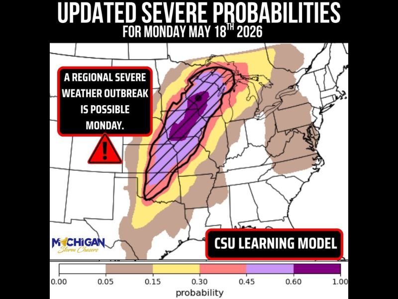
Regional Severe Weather Outbreak Possible Across Upper Midwest Including Michigan Wisconsin Iowa and Kansas With Tornadoes Large Hail and Damaging Winds Monday May 18
UPPER MIDWEST — A regional severe weather outbreak is possible on Monday, May 18, 2026, across a large corridor stretching from the Plains through the corn belt and upper Midwest. Storms developing Monday afternoon and evening will initially be isolated supercells capable of very large 2-inch-plus hail, damaging winds, and a few tornadoes across the upper peninsula stretching back through eastern Kansas, Iowa, and Wisconsin. The CSU learning model is keying in on the upper Michigan peninsula southward through the Plains as the highest risk corridor for Monday’s event.
Isolated Supercells Fire Monday Afternoon Before Growing Into Organized Squall Line
Storms will first develop as isolated supercells Monday afternoon and evening across the Plains through the upper Midwest, posing the greatest risk for very large hail and tornadoes during this initial phase. As the evening progresses, these storms are expected to grow upscale into an organized squall line that pushes eastward into lower Michigan overnight.
The squall line phase brings damaging winds and a few tornadoes as the primary threats during the nocturnal hours of Monday night into Tuesday morning.
All Hazards in Play With Damaging Winds Large Hail and Tornadoes All on the Table
All modes of severe weather are on the table for Monday across the outlined risk zone, including damaging winds, large hail, and tornadoes. Atmospheric factors including a capping inversion will help dictate which specific areas see which hazards, and those details will be refined in forthcoming forecast updates as Monday approaches.
Abundant storm fuel remains in place even after sunset with a warm and humid atmosphere supporting continued storm activity well into Monday night.
Southeast Michigan Faces Elevated Risk Tuesday as Squall Line Races Eastward Overnight
Residents in southeast Michigan face a potentially elevated severe weather risk as the organized squall line races eastward overnight Monday into Tuesday morning. Damaging winds and a few tornadoes are the primary concerns during this nocturnal phase as the storm complex maintains intensity while pushing into the lower Michigan corridor.
With this event still three to four days out, uncertainty remains on specific timing and hazard distribution. Residents across Michigan, Wisconsin, Iowa, and eastern Kansas should monitor forecast updates daily and have shelter plans confirmed well before Monday arrives. Stay with NapervilleLocal.com for the latest weather updates and local forecast coverage.

I’ve lived in Naperville long enough to see how quickly our community changes — from new developments downtown to sudden shifts in our Midwest weather. Reporting on Naperville news and daily forecasts gives me the chance to keep neighbors informed about what really matters. My goal is simple: deliver clear, timely updates so you always know what’s happening in our city and what to expect from the skies above.