
Severe Weather Upgraded to Level 4 for Northwest Indiana Including Gary, Rensselaer, and Lafayette With EF-3 Tornadoes, 75+ MPH Winds, and 2-Inch Hail Wednesday Evening
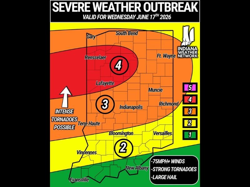
INDIANA — A severe weather outbreak is expected to unfold across Indiana this Wednesday, June 17, with the Storm Prediction Center upgrading northwest Indiana to a Level 4 of 5 Moderate Risk — one of the rarest risk designations issued anywhere in the country. A large Level 3 Enhanced Risk covers much of central and northern Indiana. Storms are expected to fire during the early evening around 5 to 7 PM ET, beginning in northwest Indiana and moving southeast through the state, clearing southeast Indiana by approximately 3 AM Thursday.
Level 4 Zone Covers Gary, Rensselaer, and Lafayette Corridor
The Level 4 Moderate Risk zone is centered over northwest Indiana, encompassing Gary, Rensselaer, and Lafayette — the area facing the highest probability of intense tornadoes, destructive winds exceeding 75 mph, and very large hail up to 2 inches in diameter. The outbreak graphic explicitly labels intense tornadoes as possible within this zone.
Strong EF-2 to intense EF-3 tornadoes are listed as the tornado hazard for this event, making this one of the more serious tornado setups Indiana has faced in recent years.
Level 3 Enhanced Risk Covers Indianapolis, Muncie, and Fort Wayne
The broader Level 3 Enhanced Risk zone covers central and northern Indiana including Indianapolis, Muncie, Fort Wayne, Terre Haute, and Bloomington. This area faces the same hazard suite of 75 mph winds, strong tornadoes, and large hail, though at a lower overall probability than the Level 4 core zone.
South-central Indiana including Vincennes, Versailles, and New Albany falls within a Level 2 Slight Risk, with 75 mph winds, strong tornadoes, and large hail all still possible.
Storms Fire 5 to 7 PM ET and Push Southeast Through Overnight
The primary storm window opens around 5 PM ET Wednesday and pushes southeast through the state overnight, clearing southeast Indiana by 3 AM Thursday. Morning clouds or rain could serve as the main fail mode if they limit storm fuel ahead of the main line.
Have shelter plans fully in place before 5 PM Wednesday and keep weather alerts active through the overnight hours. Stay with NapervilleLocal.com for the latest weather updates and local forecast coverage.

I’ve lived in Naperville long enough to see how quickly our community changes — from new developments downtown to sudden shifts in our Midwest weather. Reporting on Naperville news and daily forecasts gives me the chance to keep neighbors informed about what really matters. My goal is simple: deliver clear, timely updates so you always know what’s happening in our city and what to expect from the skies above.