
Stronger Storms Target Southern Alabama Saturday Morning as Central Alabama Stays Mostly Dry Today Before Late Weekend Rain Returns
ALABAMA — Central Alabama is expected to stay mostly dry today with a gradual increase in clouds, highs in the 70s, and only isolated showers possible through the evening. The better chance for rain and storms arrives well after midnight as activity increases from south to north. Stronger storms appear most focused across the southern half of Alabama Saturday morning, with heavy rain, lightning, gusty winds, and loud thunder possible.
Mostly Dry Today With Clouds Increasing Across Central Alabama
Most of Central Alabama should avoid widespread rain today, though clouds will continue to increase through the day. Temperatures are expected to remain comfortable, with afternoon highs mainly in the 70s.
Only isolated showers are possible through the evening. The more meaningful rain and storm chance does not arrive until after midnight, when activity begins lifting northward.
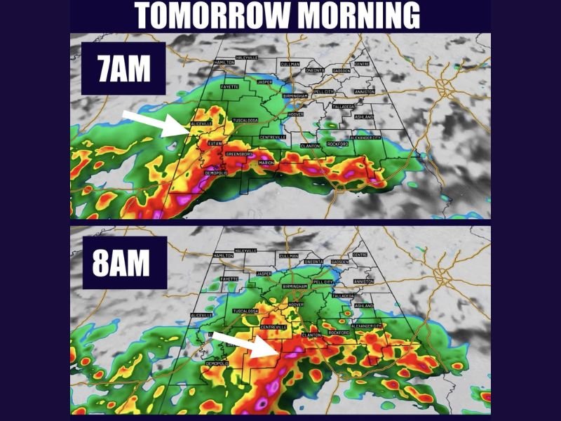
Stronger Storms Focus South Early Saturday Morning
The main storm window arrives early Saturday morning, especially across the southern half of the region. The forecast image shows heavier rain and storms near areas including Demopolis, Greensboro, Marion, Clanton, Rockford, and Centreville around 7 a.m. to 8 a.m.
Some storms during this period could produce heavy rain, frequent lightning, gusty winds, and loud thunder. The severe threat remains low, but a stormy start is possible in spots.
Hit or Miss Showers Continue South of I-20 Saturday
During the day Saturday, conditions should improve at times with some breaks in the rain. Scattered hit-or-miss showers and storms may still develop, especially south of I-20.
This does not look like a complete washout for everyone. Outdoor plans may still be possible, but radar trends will be important for anyone traveling south for Mother’s Day weekend.
Another Rain Window Arrives Late Sunday Into Monday
Sunday should bring more breaks, but rain chances are not completely finished. Another window for increased showers and storms may arrive late Sunday into Monday morning.
Drier and sunnier weather is expected to return next week after the late weekend system moves through. Until then, southern Alabama remains the area to watch most closely for stronger storm activity. Stay with NapervilleLocal.com for the latest weather updates and local forecast coverage.

I’ve lived in Naperville long enough to see how quickly our community changes — from new developments downtown to sudden shifts in our Midwest weather. Reporting on Naperville news and daily forecasts gives me the chance to keep neighbors informed about what really matters. My goal is simple: deliver clear, timely updates so you always know what’s happening in our city and what to expect from the skies above.