
Tornado Outbreak Threat Confirmed by SPC Across Kansas Nebraska Iowa and Illinois Including Wichita Kansas City Omaha Des Moines and Chicago With Significant Tornado Hatch Area Issued Monday May 18
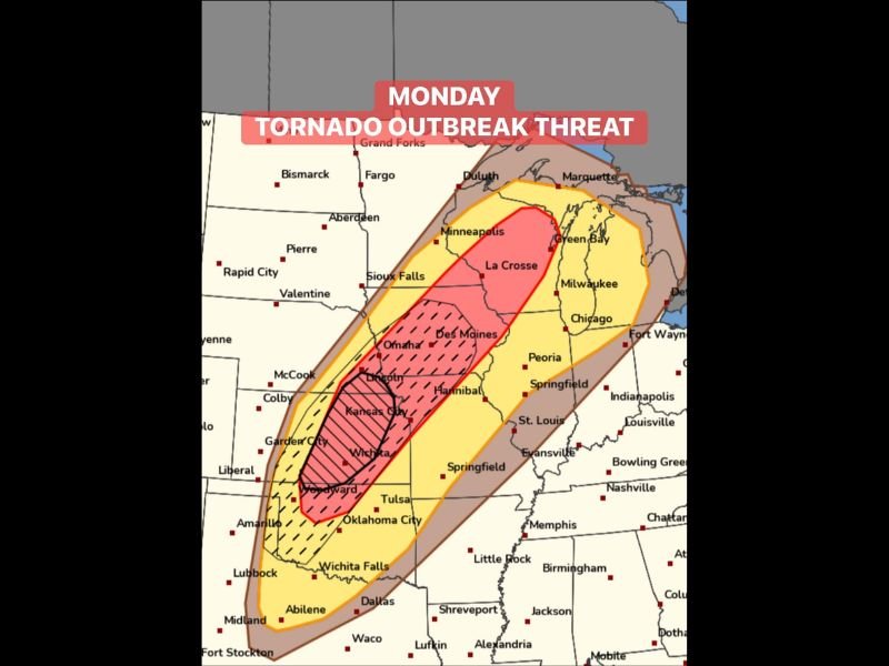
CENTRAL PLAINS — The Storm Prediction Center has issued a Day 3 Level 2 significant severe weather hatch area for Monday, May 18, 2026 — the first time this designation has been used for this event — covering the corridor from Wichita, Kansas northward through Lincoln, Nebraska. The black-hatched significant tornado zone sits inside a pink high-risk core stretching from Oklahoma City and Wichita through Kansas City, Omaha, and Des Moines, surrounded by a broader yellow enhanced risk zone extending through Chicago, Milwaukee, Minneapolis, and St. Louis. Monday is shaping up to be one of the most significant tornado outbreak threats the central United States has seen this season.
SPC Issues Significant Tornado Hatch Area From Wichita Through Lincoln for Monday
The black-hatched significant tornado area covering Wichita through Kansas City and Lincoln represents the SPC’s highest confidence zone for violent and long-track tornado potential on Monday. This designation is reserved for setups where the probability of significant tornadoes is elevated well above a typical severe weather day and signals that EF-2 or stronger tornadoes are expected across the hatched corridor.
Communities directly inside the hatch zone including Wichita, Kansas City, and Lincoln face the most serious tornado threat and should treat Monday as a potentially life-threatening severe weather situation.
Pink High Risk Core Extends Through Omaha Des Moines and Kansas City Corridor
Surrounding the significant hatch zone, the pink high-risk core covers a large swath from Oklahoma City and Woodward northward through Kansas City, Omaha, and Des Moines. This zone carries extremely high severe weather probability and encompasses millions of people across Kansas, Nebraska, Missouri, and Iowa who face a dangerous Monday afternoon and evening.
The scale and intensity of the pink zone alongside the black hatch designation confirms that Monday’s event has genuine outbreak potential across multiple states simultaneously.
Broader Risk Zone Fans Through Chicago Milwaukee Minneapolis and St Louis
The yellow enhanced and brown marginal risk zones fan outward through Chicago, Milwaukee, Minneapolis, Peoria, Springfield, St. Louis, Indianapolis, and Nashville. Communities across this wider corridor face a lower but still significant severe weather threat Monday, with all hazard modes possible to varying degrees well beyond the highest risk core.
Residents across every state in the outlined risk zone must confirm shelter plans and activate weather alerts well before Monday afternoon arrives. Stay with NapervilleLocal.com for the latest weather updates and local forecast coverage.

I’ve lived in Naperville long enough to see how quickly our community changes — from new developments downtown to sudden shifts in our Midwest weather. Reporting on Naperville news and daily forecasts gives me the chance to keep neighbors informed about what really matters. My goal is simple: deliver clear, timely updates so you always know what’s happening in our city and what to expect from the skies above.