
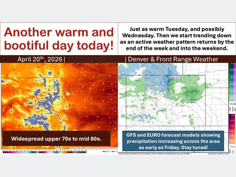
Upper 70s to Mid-80s Warming Denver and Colorado Front Range Monday Through Wednesday Before Cold Front and Precipitation Return by Friday
DENVER AND COLORADO FRONT RANGE — A warm and pleasant start to the week is underway across Denver and the Colorado Front Range on Monday April 20, 2026, with widespread upper 70s to mid-80s expected through at least Wednesday before an approaching cold front shifts the pattern heading into the weekend. Both the GFS and European models are already showing precipitation increasing across the region as early as Friday, making this week a tale of two distinct weather patterns separated by a midweek cold frontal passage.
Warm Upper 70s to Mid-80s Through Wednesday
Monday kicks off with widespread warmth across the Front Range and eastern Plains, with temperatures reaching the upper 70s to mid-80s across most locations. Tuesday will be equally warm, and Wednesday is expected to be the warmest day of the entire week before the pattern begins shifting.
A few extra clouds will filter in Monday afternoon, with light showers possible mainly over southern Colorado in the San Juans and Sangre de Cristos. East of the Continental Divide, no measurable precipitation is expected through Tuesday, with only a stray sprinkle possible Tuesday afternoon and evening.
Low-Level Jet Brings 35-45 MPH Gusts to Eastern Plains After Sunset
While daytime winds will remain manageable at 5 to 15 MPH out of the south, the low-level jet will activate after sunset bringing gusts of 35 to 45 MPH mainly across the far eastern Plains overnight. The breezy nighttime conditions will not significantly impact most Front Range communities but residents on the eastern Plains should be aware of the gusty overnight wind potential.
Wednesday will bring an additional increase in winds ahead of the approaching cold front, making it the blowiest day of the week before the front pushes through late Wednesday or early Thursday.
Cold Front Arrives Late Wednesday or Early Thursday
The weather pattern shift arrives with a cold front expected late Wednesday or early Thursday. The storm associated with this front is expected to track north of Colorado into Wyoming and Nebraska, meaning the primary impact for the vast majority of Front Range and eastern Plains residents will be gusty winds and cooler temperatures rather than significant precipitation.
Temperatures will trend noticeably downward heading into Thursday and Friday as the cold air settles in behind the departing front across the region.
GFS and Euro Models Show Precipitation Increasing by Friday
The more interesting part of the week arrives Friday and into the weekend, with both the GFS and European models showing precipitation chances increasing across Colorado as early as Friday. A stalled storm system moving into southern Canada is expected to create a favorable pattern for precipitation and cooler temperatures that could extend into next week.
Residents should stay tuned for updated forecasts as timing and precipitation details become clearer through the week. Stay with NapervilleLocal.com for the latest weather updates and local forecast coverage.

I’ve lived in Naperville long enough to see how quickly our community changes — from new developments downtown to sudden shifts in our Midwest weather. Reporting on Naperville news and daily forecasts gives me the chance to keep neighbors informed about what really matters. My goal is simple: deliver clear, timely updates so you always know what’s happening in our city and what to expect from the skies above.