
Warm Spell Expected Across Illinois, Indiana, Ohio, and Much of the Midwest as Christmas Forecast Shows Significant Positive Temperature Anomalies
ILLINOIS — A growing body of long-range forecast data suggests Christmas week may trend unusually warm across Illinois, Indiana, Ohio, and large parts of the Midwest, raising the possibility of what some meteorologists jokingly call “Torchmas.” After the early-season cold outbreaks, models now show a thaw developing next week, followed by a broader warm pattern extending toward the holiday.
Models Suggest a Strong Thaw Developing Before Christmas
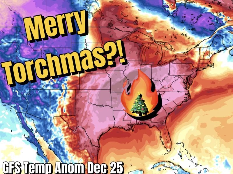
The latest temperature anomaly projections show a pronounced area of above-normal warmth stretching from the central Plains through the Midwest and into the Great Lakes. This warm signal appears clearly on the GFS map for December 25, with widespread red and orange shading covering Illinois, Indiana, Missouri, Iowa, and Ohio — indicating temperatures well above climatological averages.
Meteorologists caution that while forecasting Christmas weather this far out remains challenging, the early signals consistently point toward a milder pattern, not a wintry one. For snow lovers, the message is clear: no major snowfall threats appear on the horizon as the warming trend begins strengthening next week.
Why This Warm Pattern May Persist Through the Holiday
Forecasters note that this warm signal is not unprecedented. Similar long-range setups emerged around Thanksgiving, when early model runs hinted at a major Arctic outbreak that ultimately never materialized.
This time, the persistent ensemble trends show the atmospheric pattern strongly favoring warmth rather than early-winter cold. The lack of strong blocking and the retreat of Arctic air masses support a mild Christmas scenario for millions in the Midwest.
Even though it is too early to call this forecast definitive, meteorologists describe it as irresponsible to ignore the trend, as multiple long-range indicators are aligned in the same direction.
The Ironic Side of a Warm Christmas Forecast
For many, Christmas is the one day of the year when even people who dislike snow wouldn’t mind seeing a few flakes. The possibility of a warm, snow-free holiday carries a certain meteorological irony, especially following an early-season Arctic blast.
A warm Christmas does not rule out future winter storms — it simply means that Mother Nature’s timing may deliver mild air at the most symbolically wintery moment of the year.
As the holiday approaches and long-range signals continue to evolve, stay connected to NapervilleLocal.com for updated forecasts, winter trend analysis, and detailed regional outlooks for Illinois and surrounding states.

I’ve lived in Naperville long enough to see how quickly our community changes — from new developments downtown to sudden shifts in our Midwest weather. Reporting on Naperville news and daily forecasts gives me the chance to keep neighbors informed about what really matters. My goal is simple: deliver clear, timely updates so you always know what’s happening in our city and what to expect from the skies above.