
Weather Pattern Shift to Bring Extended Mild Conditions Across Illinois, Indiana and Ohio as the Jet Stream Realigns and the EPO Turns Deeply Positive
UNITED STATES — A major weather pattern shift is expected across Illinois, Indiana, Ohio, and the broader Midwest following this weekend’s Arctic blast, as the jet stream reorganizes into a configuration favoring milder temperatures and reduced snowfall potential. Long-range models and upper-air charts indicate that the atmosphere is sliding into a pattern similar to past mild winters.
Jet Stream Realignment Signals Warmer Days for Midwest States
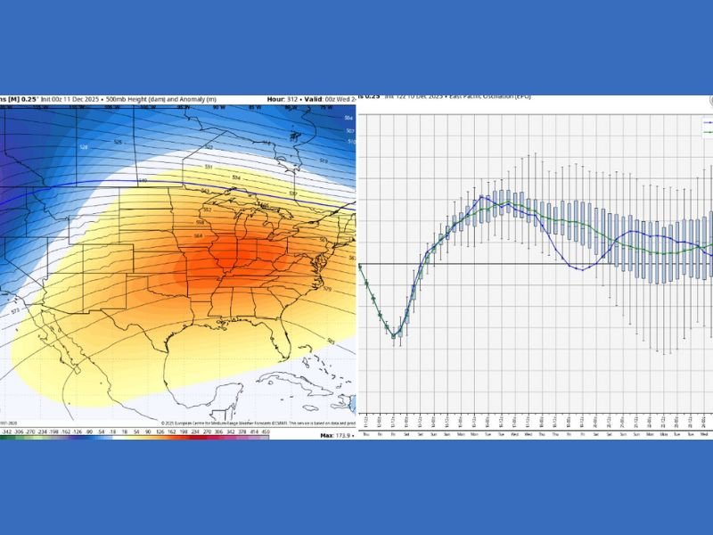
A new set of model projections shows widespread 500mb height rises across the central and eastern United States, including Illinois, Indiana, Ohio, Michigan, Wisconsin, and Iowa. This shift usually leads to surface warming, calmer weather, and fewer cold outbreaks.
Meteorologists note that this pattern has produced several mild winters in recent years, and the current maps suggest that no major snow events are expected anytime soon. Even minor snow signals have disappeared from medium-range guidance.
While the shift is not permanent, atmospheric changes of this scale typically last several weeks before colder air masses return.
EPO Turning Deeply Positive: Key Driver of the Warming Trend
The Eastern Pacific Oscillation (EPO) — a major climate driver — is projected to turn deeply positive, a phase strongly associated with mild winter conditions across the Midwest and Great Lakes region.
When the EPO becomes positive, Arctic air is less likely to spill south, allowing ridging to develop over the central United States. This is reflected in the model image showing warm anomalies stretching across the Plains, Midwest, and East.
Forecast ensemble graphs also show a steady warming trend, confirming that temperatures will rise after the Arctic blast departs.
What Midwest Residents Should Expect Going Forward
For residents of Illinois, Indiana, and Ohio, this pattern change means:
- Reduced chances for snowfall for several weeks
- More mild afternoons, with temperatures trending above seasonal averages
- Lower risk of Arctic intrusions in the near term
- Calmer travel conditions across the Midwest
Meteorologists stress that this type of mild phase does not eliminate future winter storms — it only delays them. The pattern may flip again later in the season as large-scale atmospheric conditions evolve.
As the winter outlook continues to shift, stay connected to NapervilleLocal.com for updated long-range forecasts, climate pattern analysis, and Midwest weather insights.

I’ve lived in Naperville long enough to see how quickly our community changes — from new developments downtown to sudden shifts in our Midwest weather. Reporting on Naperville news and daily forecasts gives me the chance to keep neighbors informed about what really matters. My goal is simple: deliver clear, timely updates so you always know what’s happening in our city and what to expect from the skies above.