
Iowa Braces for Sharp Temperature Drop Tonight as Arctic Cold Front Sweeps Across the State
IOWA — A strong cold front moving across the state this evening is expected to bring a rapid and significant drop in temperatures as Iowans head into New Year’s Day. Forecast data shows the coldest air arriving shortly after sunset, with temperatures plunging into the single digits across northern Iowa and the teens across central and southern Iowa by early Thursday morning.
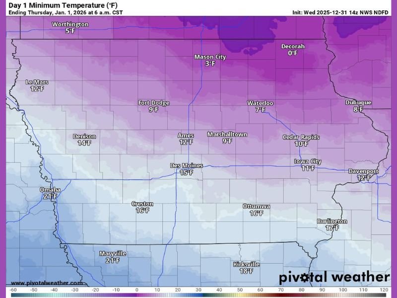
Arctic Air Will Deliver the Coldest Night of the Season
Meteorologists highlight that northern Iowa will feel the brunt of the cold air mass first. Cities such as:
- Decorah: 0°F
- Mason City: 3°F
- Fort Dodge: 9°F
will experience dangerously cold conditions, with wind chills likely dropping even lower.
Farther south, areas including Des Moines (15°F), Ames (12°F), Ottumwa (16°F) and Burlington (17°F) will also see a dramatic temperature slide compared to recent days.
New Year’s Eve Celebrations May Be Impacted
Those heading out for New Year’s Eve festivities are urged to bundle up heavily, as the coldest air arrives shortly after sunset. Roads and walkways may become slick in spots due to frost and rapidly falling temperatures.
Key reminders for residents spending time outdoors tonight:
- Wear insulated winter clothing, gloves, and hats.
- Limit time outside during late-night celebrations.
- Check on elderly neighbors and anyone without reliable heat.
Coldest Readings Expected by Early Thursday
By 6 a.m. Thursday, temperatures will bottom out statewide:
- Northern Iowa: Single digits and near-zero lows
- Central Iowa: Upper single digits to mid-teens
- Southern Iowa: Mid to upper teens
This cold plunge marks the first of several bursts of Arctic air expected to impact the region as the new year begins. Stay updated with more weather coverage and safety information at NapervilleLocal.com.

I’ve lived in Naperville long enough to see how quickly our community changes — from new developments downtown to sudden shifts in our Midwest weather. Reporting on Naperville news and daily forecasts gives me the chance to keep neighbors informed about what really matters. My goal is simple: deliver clear, timely updates so you always know what’s happening in our city and what to expect from the skies above.