
Tornadoes Wind Gusts Over 75 MPH and 2 Inch Hail Targeting Northeastern Colorado Kansas and Nebraska With All-Mode Supercells Monday June 8th
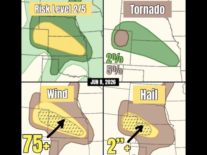
NORTHEASTERN COLORADO, KANSAS AND NEBRASKA — A significant severe weather setup is underway across Colorado, Kansas, and Nebraska Monday June 8th, with northeastern Colorado carrying the greatest tornado potential where a couple of supercells capable of all storm modes are expected to fire. The outlook places a Risk Level 2 of 5 yellow zone covering a large corridor from northeastern Colorado through western Kansas and into Nebraska, with a five percent tornado probability hatched zone centered over northeastern Colorado.
Storms are expected to grow upscale through the afternoon and transition into primarily strong wind producers with gusts potentially exceeding 75 mph.
Northeastern Colorado the Bullseye for Tornado Potential With 5 Percent Probability
The five percent tornado hatched zone is tightly concentrated over northeastern Colorado, where discrete supercells firing in the afternoon will carry the highest potential for tornado development before growing upscale. The broader two percent tornado probability zone extends northeastward across western Nebraska and into southern South Dakota, covering a large geographic footprint of tornado-capable storm potential.
Any tornadoes are expected below EF-2 intensity, but supercells in all-mode environments can produce significant brief tornadoes with limited warning time.
Wind Gusts Exceeding 75 MPH Become the Primary Threat as Storms Upscale
The hatched wind probability zone covering northeastern Colorado into western Kansas and Nebraska indicates high confidence in wind gusts exceeding 75 mph as the storm complex grows upscale and transitions from discrete supercells into a more linear and wind-dominant mode. Wind gusts at this magnitude cause widespread structural damage, down trees and power lines, and create extremely dangerous travel conditions.
The hatched hail zone in the same area also shows 2 inch plus hail potential during the initial discrete supercell phase before the wind threat takes over.
Southern Illinois Also Watching for a Tornado or Two Monday
Separate from the primary Colorado and Plains threat, far southern Illinois also carries a tornado or two potential Monday as additional severe storms are possible across that region. Residents across far southern Illinois should monitor local forecast updates and have ways to receive warnings active throughout the afternoon and evening hours as the secondary severe weather threat develops. Stay with NapervilleLocal.com for the latest weather updates and local forecast coverage.

I’ve lived in Naperville long enough to see how quickly our community changes — from new developments downtown to sudden shifts in our Midwest weather. Reporting on Naperville news and daily forecasts gives me the chance to keep neighbors informed about what really matters. My goal is simple: deliver clear, timely updates so you always know what’s happening in our city and what to expect from the skies above.