
Noisy Storm Complex Entering Northwest Arkansas Including Springdale and Harrison With Heavy Rain Lightning and Wind Drifting Toward Little Rock by Midday Monday
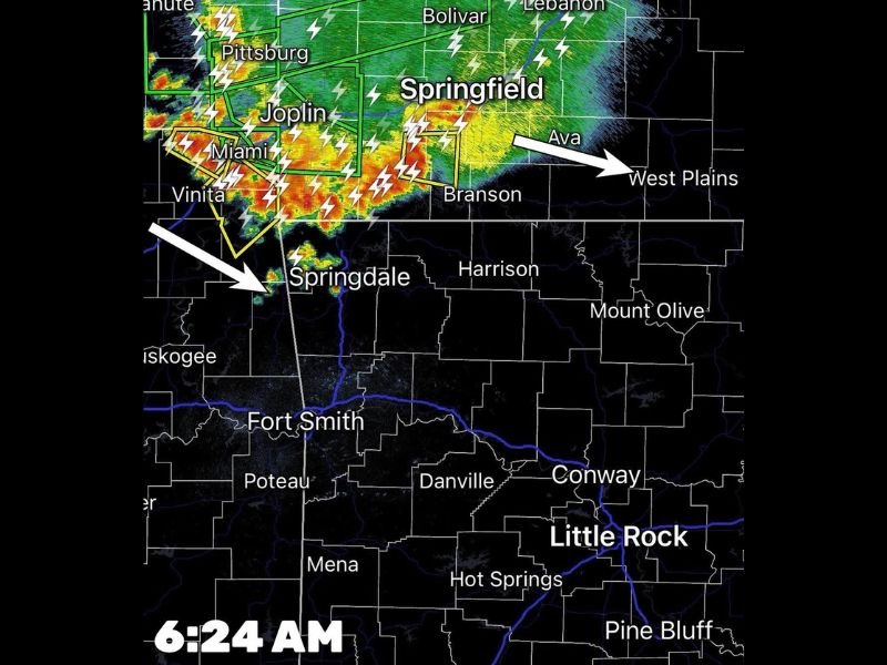
NORTHWEST ARKANSAS — A complex of very noisy and active storms is entering northwest Arkansas Monday morning as forecasted, with radar at 6:24 AM showing intense red, orange, and yellow returns pushing southeastward from the Joplin and Springfield Missouri corridor directly toward Springdale and Harrison. Heavy rain, frequent lightning, and gusty winds are the primary hazards with this storm complex as it moves through the region during the morning hours.
Forecasters are watching the system closely, hoping storms somewhat behave and do not intensify further as they push deeper into Arkansas.
Storm Complex Crossing Into Northwest Arkansas From Missouri as of 6:24 AM
The 6:24 AM radar image clearly shows the storm complex straddling the Arkansas and Missouri border, with the leading edge pushing toward Springdale and the broader northwest Arkansas corridor. Tracking arrows indicate the system is moving southeastward toward West Plains and Branson while simultaneously pushing directly into Springdale from the northwest.
The storm complex is producing intense lightning activity visible across the entire leading edge of the system from Pittsburg and Joplin southward through Miami, Vinita, and into northwest Arkansas.
Heavy Rain Lightning and Wind the Main Hazards Through the Morning
The primary hazards associated with this storm complex are heavy rainfall, frequent lightning strikes, and gusty winds rather than a significant organized severe weather threat at this time. The system is described as very noisy with the noise referring to the intense lightning activity and heavy rain rather than a formal severe weather designation.
Residents across Springdale, Harrison, Fayetteville, and surrounding northwest Arkansas communities should remain indoors during the heaviest activity and avoid unnecessary travel through the morning hours.
Storms Expected to Drift Southeast Into Central and Eastern Arkansas by Midday
The storm complex is expected to continue drifting southeastward through the morning and could make it into central and eastern Arkansas including the Conway, Little Rock, and Hot Springs corridor by midday. Fort Smith and surrounding communities along the I-40 corridor sit in the path of the advancing system and should prepare for heavy rain and lightning impacts during the late morning hours.
Monitor the Arkansas Weather Network for real-time radar updates as the complex advances. Stay with NapervilleLocal.com for the latest weather updates and local forecast coverage.

I’ve lived in Naperville long enough to see how quickly our community changes — from new developments downtown to sudden shifts in our Midwest weather. Reporting on Naperville news and daily forecasts gives me the chance to keep neighbors informed about what really matters. My goal is simple: deliver clear, timely updates so you always know what’s happening in our city and what to expect from the skies above.