
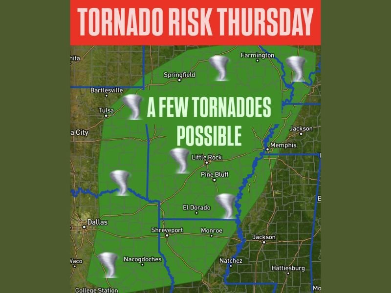
Low-End Tornado Risk Introduced Thursday From Oklahoma and Texas Into the Mid-South and Illinois
EASTERN OKLAHOMA AND EAST TEXAS — A low-end tornado risk has been introduced for Thursday, stretching from eastern Oklahoma and east Texas through the Mid-South and northward into Illinois, according to the latest severe weather outlook.
Forecasters say a few tornadoes are possible throughout the day, with the threat becoming more concentrated from Thursday afternoon into the nighttime hours, as atmospheric conditions gradually become more favorable.
Tornado Risk Spans Multiple States
The highlighted risk area includes portions of Oklahoma, Texas, Arkansas, Louisiana, Mississippi, Tennessee, Missouri, and Illinois. While the overall threat level remains on the lower end, the broad geographic coverage means millions of residents could experience strong to severe thunderstorms. Cities shown within the risk zone include Tulsa, Little Rock, Shreveport, Monroe, Jackson, Memphis, and surrounding communities.
Strongest Window Expected Later in the Day
Meteorologists indicate the highest tornado potential will occur from the afternoon into the evening and overnight hours. During this time, storms may become better organized, increasing the chance that rotating storms could briefly produce tornadoes. Even outside the peak window, isolated tornadoes cannot be ruled out earlier in the day.
Residents Urged to Stay Weather-Aware
Because tornadoes can develop quickly, residents across the affected region are urged to stay weather-aware and ensure they have multiple ways to receive warnings, especially during nighttime hours when severe weather can be more dangerous.
Conditions will continue to be monitored as Thursday approaches, and adjustments to the risk area remain possible. For continued updates on developing severe weather threats across the country, visit NapervilleLocal.com, and share how conditions are unfolding where you live.

I’ve lived in Naperville long enough to see how quickly our community changes — from new developments downtown to sudden shifts in our Midwest weather. Reporting on Naperville news and daily forecasts gives me the chance to keep neighbors informed about what really matters. My goal is simple: deliver clear, timely updates so you always know what’s happening in our city and what to expect from the skies above.