
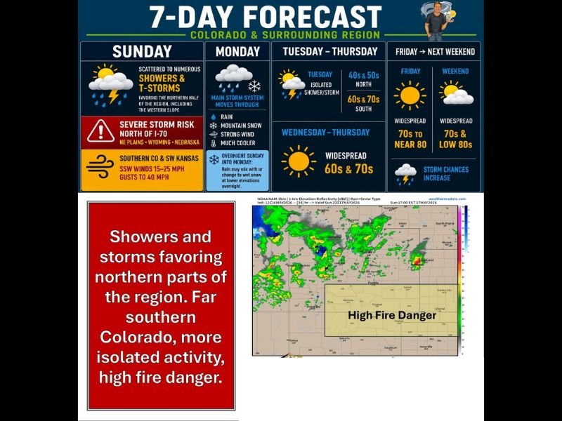
Severe Storm Risk and High Fire Danger Across Colorado Including Denver Front Range and NE Plains With Rain Snow and Strong Winds Arriving Monday
COLORADO — A complex and active weather pattern is unfolding across Colorado and surrounding region Sunday through Monday, with severe storm risk north of I-70 across the NE plains, Wyoming, and Nebraska while high fire danger grips far southern Colorado and SW Kansas. Monday brings the main storm system with rain, mountain snow, strong winds, and much cooler temperatures crashing into the region. Southern Colorado faces gusts to 40 mph and high fire danger today while northern areas deal with severe storm potential.
Severe Storm Risk North of I-70 With Damaging Winds Large Hail and Tornadoes Possible
Scattered to numerous showers and thunderstorms are developing across the northern half of Colorado, favoring the Front Range, western slope, and NE plains through Sunday. The strongest storms north of I-70 across the NE plains, Wyoming, and Nebraska carry the potential for damaging winds, large hail, and brief tornadoes through the afternoon and evening.
Storm activity will continue in waves through Sunday night and into Monday ahead of the approaching main storm system.
High Fire Danger Across Southern Colorado and SW Kansas With Gusts to 40mph
Far southern Colorado including the San Luis Valley, Wet Mountains, and SE plains along with SW Kansas are under high fire danger today with SSW winds gusting to 40 mph. Any new fire starts in this zone could spread rapidly given the combination of strong winds, low humidity, and dry fuels across the region.
Residents across southern Colorado and SW Kansas should avoid any outdoor burning and report any fire activity immediately.
Main Storm System Monday Brings Rain Mountain Snow Strong Winds and Sharp Cooldown
Monday brings a dramatic pattern shift as the main storm system moves through Colorado, delivering rain, mountain snow, strong winds, and significantly cooler temperatures statewide. Overnight Sunday into Monday, rain may mix with or change to wet snow at lower elevations including potentially along I-25 and the Cheyenne Ridge.
Tuesday through Thursday moderate into the 40s and 50s north and 60s and 70s south before widespread 70s and low 80s return by the weekend. Stay with NapervilleLocal.com for the latest weather updates and local forecast coverage.

I’ve lived in Naperville long enough to see how quickly our community changes — from new developments downtown to sudden shifts in our Midwest weather. Reporting on Naperville news and daily forecasts gives me the chance to keep neighbors informed about what really matters. My goal is simple: deliver clear, timely updates so you always know what’s happening in our city and what to expect from the skies above.