
Alabama Storm Timing Becomes Clearer as Heavy Rain and Strong Winds Target Friday Into Saturday
ALABAMA — Weather models are beginning to better define the timing and impact of a slow-moving storm system expected to affect much of Alabama from Friday afternoon through Saturday morning, bringing periods of heavy rain, gusty winds, and the possibility of a few stronger storms.
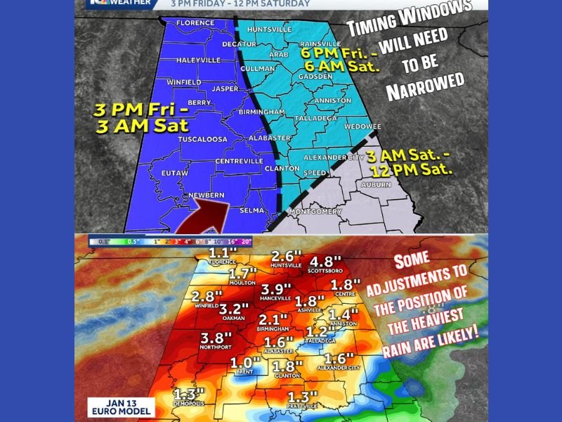
As of Wednesday morning, forecasters say this is an initial estimate of timing, and adjustments are still likely. Because the system is moving slowly, rain and storms will take several hours to pass through the state rather than moving through quickly in a narrow window.
Heavy Rain Appears to Be the Main Threat
Current guidance suggests widespread rain will be the primary concern across central and north Alabama. Rainfall totals shown in the latest model data indicate multiple rounds of rain, with some areas potentially receiving 1 to 4 inches by the time the system exits.
Forecasters note that the exact placement of the heaviest rain bands may still shift, but the signal for a soaking rain event remains strong.
Severe Weather Risk Currently Limited but Not Zero
At this time, the setup appears to favor heavy rain and non-severe storms, though meteorologists caution that an isolated stronger or severe storm cannot be ruled out, especially late Friday night into early Saturday morning. Any severe threat would likely be embedded within a larger area of rain rather than appearing as a widespread severe outbreak.
Day-by-Day Breakdown Based on Current Data
Wednesday:
Dense fog during the morning hours with some patchy drizzle. Temperatures warm into the upper 60s to low 70s under a mix of clouds and sun.
Thursday:
Warm and increasingly humid. A few spotty showers are possible. Southerly winds strengthen ahead of the approaching system, with gusts reaching 20 to 25 mph. Highs rise into the lower 70s, well above average for January.
Friday:
Breezy and warm with highs near 70 degrees. Isolated showers may develop during the day, but rain and storms become more widespread Friday night, continuing into early Saturday. Some storms could be strong.
Saturday:
Showers and storms shift south through the morning hours before ending by early afternoon. Cooler air moves in behind the cold front, with temperatures falling into the 50s.
Sunday:
Dry and noticeably cooler. Morning lows near freezing, with afternoon highs in the upper 40s to low 50s under sunny skies.
Monday:
A freeze is possible across much of central and north Alabama, with lows dropping into the upper 20s and low 30s. Highs remain cool, topping out in the upper 40s to low 50s.
Bottom Line
A prolonged period of rain is expected across Alabama late this week, with Friday night into Saturday morning being the most active timeframe. While the severe weather risk appears limited right now, forecast updates are likely as models refine storm placement and timing. Residents are encouraged to continue checking updates through the week as the system approaches and details become clearer.

I’ve lived in Naperville long enough to see how quickly our community changes — from new developments downtown to sudden shifts in our Midwest weather. Reporting on Naperville news and daily forecasts gives me the chance to keep neighbors informed about what really matters. My goal is simple: deliver clear, timely updates so you always know what’s happening in our city and what to expect from the skies above.