
Central Texas Set for Sharp Temperature Drop as Strong Cold Front Brings Below-Freezing Wind Chills Into Hill Country Saturday Morning
United States — A strong cold front is poised to sweep across Central Texas, bringing a return to winter conditions Friday night and producing below-freezing wind chills across the Hill Country early Saturday morning. After recent milder days, this sharp temperature change will bring a brief but notable burst of cold air to the region.
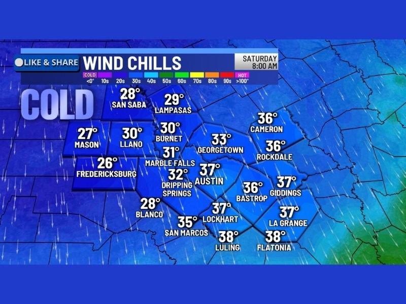
Forecast data shows widespread wind chills in the 20s and 30s by Saturday morning, marking one of the colder starts of the month for Central Texas communities.
Wind Chills Fall Into the 20s and 30s Across Central Texas
Saturday morning’s wind chills, based on the latest forecast map, include:
- San Saba: 28°F
- Lampasas: 29°F
- Mason: 27°F
- Llano: 30°F
- Burnet: 30°F
- Marble Falls: 31°F
- Fredericksburg: 26°F
- Blanco: 28°F
- Dripping Springs: 32°F
- Austin: 37°F
- Georgetown: 33°F
- San Marcos: 35°F
- Lockhart: 37°F
- Bastrop: 36°F
- Rockdale: 36°F
- Cameron: 36°F
- Giddings: 37°F
- La Grange: 37°F
- Luling: 38°F
- Flatonia: 38°F
These values highlight a broad area of cold, with the Hill Country seeing the lowest wind chills, dipping well below freezing in several locations.
Cold Front Arrives Friday and Intensifies Overnight
The cold front is expected to move through the region Friday, pulling in noticeably colder and drier air. As winds pick up behind the front, temperatures will feel significantly colder overnight.
This setup typically brings:
- Rapid temperature drops after sunset
- Gusty north winds driving wind chill values lower
- Clearer skies that allow temperatures to fall sharply
- A cold start to the weekend, especially for early-morning activities
The contrast between Friday daytime conditions and Saturday morning’s wind chills may be particularly noticeable for residents accustomed to recent mild weather.
Hill Country Expected to See the Most Intense Cold
The Hill Country’s elevation and terrain often enhance cold air effects, making below-freezing wind chills more common during early winter fronts. Locations such as:
- Fredericksburg
- Mason
- Blanco
- Llano
- San Saba
are among the coldest on the map and will likely experience the most significant chill Saturday morning.
Residents in these areas should prepare for:
- A colder-than-normal start to the weekend
- Early-morning frost potential
- Wind-driven cold that feels sharper than actual air temperatures
What Central Texas Residents Should Keep in Mind
Even without winter precipitation, wind chills in the 20s and 30s can impact:
- Early-morning commutes
- Outdoor workers
- Pets and livestock
- Sensitive plants
- Weekend travel and outdoor plans
Layered clothing and cold-weather preparation are recommended for Saturday morning.
Looking Ahead
This cold surge appears brief, with temperatures expected to rebound gradually after the weekend. However, it represents a clear return to winter conditions for Central Texas as the season progresses.
NapervilleLocal.com will continue monitoring national weather developments and provide updates as more cold fronts and pattern changes emerge across the country.

I’ve lived in Naperville long enough to see how quickly our community changes — from new developments downtown to sudden shifts in our Midwest weather. Reporting on Naperville news and daily forecasts gives me the chance to keep neighbors informed about what really matters. My goal is simple: deliver clear, timely updates so you always know what’s happening in our city and what to expect from the skies above.