
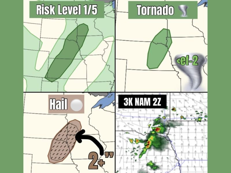
Very Large Hail Over 2 Inches and Brief Tornado Possible From Scattered Severe Storms Across Nebraska and South Dakota at Risk Level 1 This Evening Sunday May 24
NEBRASKA AND SOUTH DAKOTA — A shortwave embedded in a northwest flow regime will ignite a few scattered severe-capable storms across Nebraska and South Dakota this evening, Sunday, May 24, 2026. Storm coverage will be sparse but any cell that does develop carries the potential to easily go severe, producing very large hail of 2 inches or greater and a brief weak tornado below EF-2 intensity.
Shortwave Triggering Scattered Severe Capable Storms Across Nebraska and South Dakota Tonight
A shortwave energy pulse tracking through a northwest flow regime across the region will serve as the trigger for scattered storm development across Nebraska and South Dakota this evening. Despite the sparse overall coverage, the atmospheric environment will be supportive enough for individual storms that do fire to quickly reach severe criteria.
The 3K NAM 2Z model output shows scattered storm development depicted across the Nebraska corridor with locally intense cores possible where cells organize. The lower end severe probabilities reflect the sparse storm coverage rather than any lack of intensity potential from individual storms.
Very Large Hail of 2 Inches or Greater Threat Across Nebraska Hail Risk Zone
The hail threat across the Nebraska risk zone is significant, with 2 inches or larger hail possible from any supercell that develops this evening. The hail risk zone is depicted across a north to south oriented corridor through Nebraska, with the hatched area indicating the greatest probability for very large hail accumulation.
Residents across the Nebraska hail risk corridor should protect vehicles and any outdoor property before evening storm development begins. Hail of 2 inches or greater is capable of causing significant damage to vehicles, rooftops, and exposed equipment in a matter of minutes once a severe storm passes overhead.
Brief Weak Tornado Cannot Be Ruled Out Across the Nebraska and South Dakota Risk Zone
Beyond the hail threat, a brief and weak tornado below EF-2 intensity cannot be ruled out across the active risk zone covering Nebraska and South Dakota this evening. The tornado risk map mirrors the overall severe risk zone, with the sparse storm coverage keeping overall tornado probability low while the quality of individual storm threats remains elevated.
Residents across both states should remain weather aware through the evening hours and have a shelter plan ready before storms develop. The quick and localized nature of this type of sparse but intense storm setup means personal preparedness is the most critical tool available when warning lead times can be short. Stay with NapervilleLocal.com for the latest weather updates and local forecast coverage.

I’ve lived in Naperville long enough to see how quickly our community changes — from new developments downtown to sudden shifts in our Midwest weather. Reporting on Naperville news and daily forecasts gives me the chance to keep neighbors informed about what really matters. My goal is simple: deliver clear, timely updates so you always know what’s happening in our city and what to expect from the skies above.