
Gulf Coast Winter Storm Risk Rises as Forecasts Show Growing Chance of Accumulating Snow This Weekend
United States — Forecast guidance is increasingly signaling a heightened winter storm risk across the Gulf Coast states this weekend, with multiple models now indicating a meaningful chance for accumulating snow, a rare setup for the region.
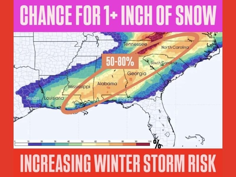
Latest projections show a broad corridor from Texas through Louisiana, Mississippi, Alabama, Georgia, and into the Carolinas falling within an elevated probability zone for winter precipitation. Some guidance places odds as high as 50–80 percent for at least one inch of snow, particularly along and north of the central Gulf Coast.
What the Latest Forecast Data Indicates
The current forecast trend highlights a strengthening winter system capable of producing snow in areas that typically see rain during cold-season events. The probability map shows a clear signal for 1 inch or more of snowfall across a wide swath of the southern United States.
Key takeaways from the data include:
- Increasing confidence in winter precipitation rather than rain
- A large, continuous impact zone, not an isolated pocket
- Snow potential extending from eastern Texas through the Southeast
This represents a notable shift compared to earlier forecasts, which showed weaker cold air and limited snow potential.
Why This Setup Is Concerning for the Gulf States
Winter storms along the Gulf Coast tend to have outsized impacts, even when snowfall totals are modest. Infrastructure, road treatment capacity, and public preparedness are all limited compared to colder regions.
Even 1 inch of snow in these states can lead to:
- Hazardous travel conditions
- Road closures and accidents
- School and government disruptions
- Delays at airports and along major highways
The broad coverage shown in the forecast increases the likelihood of regional disruptions rather than localized issues.
Areas Most at Risk This Weekend
Based on the probability shading and forecast placement, the highest concern zone currently includes:
- Southern Mississippi and Alabama
- Interior Louisiana
- Southern and central Georgia
- Parts of the Florida Panhandle
- Southern portions of Tennessee and the Carolinas
While exact snowfall totals remain uncertain, the probability of measurable accumulation is trending upward, which is why forecasters are urging closer monitoring.
What Residents Should Watch Closely
While the storm is still evolving, residents across the Gulf Coast and Southeast should prepare for the possibility of winter impacts by:
- Monitoring updated forecasts frequently
- Planning for possible travel delays
- Avoiding unnecessary trips during peak precipitation periods
- Being ready for rapid changes in road conditions
Small shifts in temperature or storm track could significantly affect which areas see snow versus cold rain, making late updates especially important.
For continued coverage of developing winter storm risks, forecast trend explanations, and regional impact updates, follow reports from NapervilleLocal.com, where we track major national weather threats and explain why they matter.

I’ve lived in Naperville long enough to see how quickly our community changes — from new developments downtown to sudden shifts in our Midwest weather. Reporting on Naperville news and daily forecasts gives me the chance to keep neighbors informed about what really matters. My goal is simple: deliver clear, timely updates so you always know what’s happening in our city and what to expect from the skies above.