
Intense Lake-Effect Snow Band Targets Northern Indiana With Potential for One to Two Feet of Snow Overnight
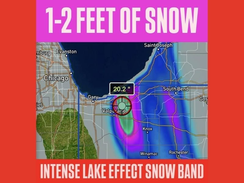
Indiana — A powerful lake-effect snow band developing off Lake Michigan is expected to deliver extreme snowfall totals across northern Indiana overnight, with some areas facing one to two feet of snow in a very short time frame, according to current radar and accumulation projections.
The narrow but intense band is forecast to remain nearly stationary, dramatically increasing the risk of rapid accumulation, near-zero visibility, and dangerous travel conditions, particularly in areas directly beneath the core of the band.
Where the Heaviest Snow Is Expected
Forecast data shows the most intense snowfall focused across north-central and northwestern Indiana, including areas south and southeast of Lake Michigan. Communities near the heart of the band could see snowfall rates of several inches per hour, allowing totals to pile up quickly.
Key risk factors include:
- A locked-in lake-effect band with little movement
- Cold air flowing across the relatively warm lake surface, fueling snow growth
- Localized totals exceeding surrounding areas by a wide margin
Even small shifts in wind direction could move the band slightly, but areas that remain under it for several hours face extreme accumulation potential.
Why This Lake-Effect Event Is Especially Dangerous
Lake-effect snow differs from traditional winter storms because of its intensity and precision. Communities just a few miles apart can experience drastically different conditions.
In this case, the setup supports:
- Blizzard-like conditions within the band
- Rapid road closures due to drifting and whiteouts
- Emergency response delays
- High risk of stranded motorists
Snowfall totals near or above one foot overnight significantly increase the likelihood of travel becoming impossible, especially on secondary roads.
Travel and Safety Impacts Expected Overnight
Officials and residents in northern Indiana should be prepared for severe travel disruptions, including:
- Roadways becoming impassable in the heaviest snow
- Vehicles getting stuck in deep, drifting snow
- Extended cleanup and plowing operations into the next day
- Possible school or business closures due to lingering impacts
Conditions may worsen quickly after sunset as snowfall rates intensify and temperatures remain cold enough to prevent melting.
What Residents Should Do Now
Those in or near the expected impact zone are urged to:
- Avoid overnight travel if possible
- Prepare for power disruptions or isolation
- Keep emergency supplies accessible
- Monitor local warnings and advisories closely
Lake-effect events can escalate faster than broader storms, leaving little time to react once conditions deteriorate.
For continued updates on significant winter weather events, evolving snowfall threats, and regional impact coverage, follow reports from NapervilleLocal.com, where we track major weather developments across the country and explain what they mean for affected communities.

I’ve lived in Naperville long enough to see how quickly our community changes — from new developments downtown to sudden shifts in our Midwest weather. Reporting on Naperville news and daily forecasts gives me the chance to keep neighbors informed about what really matters. My goal is simple: deliver clear, timely updates so you always know what’s happening in our city and what to expect from the skies above.