
Michigan Braces for a Snowy Weekend as Lake-Enhanced Clipper Targets 4–8 Inches Along Lake Superior and Lake Michigan
MICHIGAN — A fast-moving winter clipper is set to kick off a snowy stretch across the state beginning late Thursday night and continuing through Friday, January 16, with lake-enhanced snowfall expected to push totals significantly higher in northern and western areas as the system taps into cold air and favorable wind direction.
This will be Clipper #1 of the weekend, with additional systems lining up behind it, signaling that winter conditions are far from over for much of Michigan.
Lake-Enhanced Snow Sets Up Along Lake Superior and Lake Michigan
Forecast data shows west-to-northwest winds developing behind the clipper, creating an ideal setup for lake enhancement along western Lake Superior and Lake Michigan. These conditions are expected to dramatically boost snowfall totals in favored snow belts.
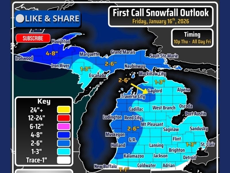
Areas immediately inland from Lake Superior — including parts of the western Upper Peninsula — could see snow totals reaching 4 to 8 inches, with isolated locations potentially pushing toward half a foot if banding becomes persistent. Along Lake Michigan, portions of northwestern and west-central Lower Michigan may also experience locally higher totals, especially where snow bands remain stationary for extended periods.
Snowfall Totals Vary Widely Across the State
While lake-enhanced regions stand to see the highest amounts, snow will be widespread statewide, with most inland locations picking up a lighter but still impactful accumulation.
Expected snowfall ranges include:
- 4–8 inches: Western Upper Peninsula and favored Lake Superior snow belts
- 2–6 inches: Northern Lower Michigan, including areas near Traverse City and Gaylord
- 1–3 inches: Central and eastern Lower Michigan, including Lansing, Detroit, and surrounding communities
- Trace to 1 inch: Far southern portions of the state
Even areas receiving lower totals may experience brief bursts of heavier snow, especially during the peak of the system on Friday.
Timing: Snow Begins Late Thursday, Continues Through Friday
Snow is expected to develop late Thursday night, intensify through Friday morning, and continue off and on throughout the day Friday as lake enhancement strengthens behind the main clipper. Forecasters caution that snowfall rates could fluctuate quickly, particularly in lake-effect bands, which may cause rapid changes in road conditions with little warning.
More Clippers Lining Up for the Weekend
This system is just the first of multiple clippers expected to impact Michigan through the weekend. Forecasters are closely monitoring whether future updates will feature separate snowfall maps or a consolidated outlook covering all upcoming systems. Updated forecasts and final snowfall adjustments are expected Friday morning as higher-resolution data becomes available.
What This Means for Residents
With cold air locked in and multiple systems approaching, residents should prepare for:
- Snow-covered and slick roads
- Rapid visibility reductions in heavier snow bands
- Cold conditions persisting through the weekend
- Repeated snow events limiting cleanup between systems
Those planning outdoor activities, especially in lake-enhanced zones, are advised to bundle up and stay weather-aware as winter conditions intensify.
For continuing winter weather updates, snowfall maps, and regional forecasts, follow the latest reports on NapervilleLocal.com and share how conditions look in your area.

I’ve lived in Naperville long enough to see how quickly our community changes — from new developments downtown to sudden shifts in our Midwest weather. Reporting on Naperville news and daily forecasts gives me the chance to keep neighbors informed about what really matters. My goal is simple: deliver clear, timely updates so you always know what’s happening in our city and what to expect from the skies above.