
Brutal Arctic Air Targets Indiana: Wind Chills Could Plunge to -25°F as Cold Weather Alerts Loom Monday
INDIANA — The coldest air mass of the 2026 winter season is surging into the region late Sunday, setting the stage for potentially dangerous wind chills across Indiana by Monday morning, with the most extreme conditions expected in northern parts of the state.
Forecast guidance indicates that wind chills may fall as low as -25°F in Northern Indiana, while sub-zero wind chills could spread statewide, creating hazardous conditions rarely seen in this region.
Why This Cold Is Different From a Typical January Chill
This is not just another cold morning. The incoming Arctic air mass is exceptionally strong, combining bitter temperatures with persistent wind, which dramatically accelerates heat loss from exposed skin.
When wind chills drop below zero:
- Frostbite can occur in minutes
- Hypothermia risk increases rapidly
- Outdoor exposure becomes dangerous without proper protection
This level of cold is uncommon in Indiana, which is why weather officials are already signaling the potential for cold weather headlines.
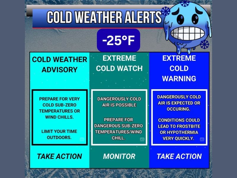
Cold Weather Advisories, Watches, or Warnings Possible
Forecasters are closely monitoring conditions for possible issuance of:
- Cold Weather Advisories
- Extreme Cold Watches
- Extreme Cold Warnings (especially across Northern Indiana)
These alerts are issued when wind chills reach levels that pose a direct threat to life and safety, not simply uncomfortable cold.
What These Cold Weather Alerts Actually Mean
Understanding the alerts matters:
- Cold Weather Advisory
Signals very cold or sub-zero wind chills. Outdoor exposure should be limited. - Extreme Cold Watch
Dangerous Arctic air is possible. Preparations should begin immediately. - Extreme Cold Warning
Life-threatening cold is expected or occurring. Frostbite and hypothermia can develop quickly.
If issued, these alerts are meant to prompt immediate action, not just awareness.
How to Prepare Before Monday Morning
Residents should take precautions now:
- Dress in multiple insulated layers
- Cover exposed skin, including face and hands
- Bring pets indoors
- Limit time outdoors, especially early Monday
- Check on vulnerable individuals
Even short exposure can become dangerous under these conditions.
Bottom Line
The coldest air of the winter is on track to arrive Sunday night, with dangerously low wind chills possible across Indiana by Monday morning. While official alerts have not yet been issued, conditions are trending toward levels that could justify cold weather advisories or warnings, particularly in northern areas.
Stay alert, prepare early, and monitor updates closely. For continued winter weather updates, clear explanations, and public safety coverage, follow the latest forecasts at NapervilleLocal.com.

I’ve lived in Naperville long enough to see how quickly our community changes — from new developments downtown to sudden shifts in our Midwest weather. Reporting on Naperville news and daily forecasts gives me the chance to keep neighbors informed about what really matters. My goal is simple: deliver clear, timely updates so you always know what’s happening in our city and what to expect from the skies above.