
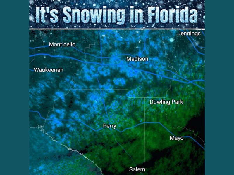
Snow Begins Falling Across North Florida as Radar Confirms Flurries Near Perry and Tallahassee Moving East and South
NORTH FLORIDA — Snow has officially begun falling across parts of North Florida, an extremely rare sight for the region, as Saturday afternoon radar imagery confirmed snow signatures moving east and south across the area.
Friends and spotters in Perry have confirmed snow reaching the ground, while Tallahassee has reported multiple instances of flurries as colder air deepens across the region. Radar imagery around 3 p.m. Saturday clearly shows blue reflectivity — typically associated with snow — spreading across inland portions of North Florida.
Radar Confirms Snow Signatures Across Inland North Florida
Weather radar shows snow activity extending across areas including Perry, Madison, Monticello, Waukeenah, Dowling Park, Mayo, and Salem, with the strongest snow signals pushing gradually east and south.
The radar depiction indicates colder air aloft is sufficient to support snow, even as surface temperatures hover near marginal levels. This setup allows flakes to reach the ground, especially in heavier bursts.
Perry and Tallahassee Among First to Report Snowfall
Observers in Perry were among the first to confirm snow reaching the ground, while Tallahassee reported scattered flurries throughout the afternoon. Although accumulations are expected to remain minimal or nonexistent, the event itself is notable given how uncommon snowfall is this far south.
Meteorologists note that even brief snow showers in North Florida require a precise alignment of cold air, moisture, and timing — all of which appear to be coming together this afternoon and evening.
Evening Could Bring Additional Flurries as Cold Air Deepens
As the system continues moving east and south, additional flurries remain possible through the evening hours. The National Weather Service office in Tampa has been discussing continued snow chances as colder air filters deeper into the region.
While significant impacts are not expected, residents may continue to see intermittent snowflakes, especially during heavier precipitation bands.
A Rare Winter Moment for North Florida
Snowfall in North Florida is a rare and memorable event, even when limited to flurries. The combination of confirmed reports and radar evidence makes this one of those unusual winter moments residents are likely to remember.
Are you seeing snowflakes where you live in North Florida? Share what you’re seeing and stay with NapervilleLocal.com for continued coverage, radar updates, and weather developments as this rare winter event unfolds.

I’ve lived in Naperville long enough to see how quickly our community changes — from new developments downtown to sudden shifts in our Midwest weather. Reporting on Naperville news and daily forecasts gives me the chance to keep neighbors informed about what really matters. My goal is simple: deliver clear, timely updates so you always know what’s happening in our city and what to expect from the skies above.