
Alabama Forecast: Warmest Week of 2026 So Far Brings 70s, Midweek Showers, Then a Wet Valentine’s Weekend
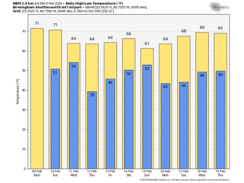
ALABAMA — A stretch of unusually mild February weather is settling in across the state, setting up what forecasters are calling the warmest week of 2026 so far for Alabama and the Deep South. After a few early sprinkles in the central counties, most communities are expected to stay mainly dry through Tuesday with afternoon highs running roughly 67–74°F.
A Warm Start: Dry Through Tuesday With Highs Near 70
The overall pattern stays mild to start the week, with the best stretch for outdoor plans expected Monday and Tuesday. Forecast guidance shows temperatures remaining comfortably above typical early-February levels, with many areas climbing into the upper 60s and low-to-mid 70s during the afternoon.
Wednesday Brings Showers, But Not a Widespread Heavy Event
A passing disturbance is expected to bring showers to Alabama on Wednesday, though the setup does not look especially intense or widespread. The expectation is for a quick “in-and-out” round of rain rather than a prolonged soaking, with conditions improving again afterward.
Thursday and Friday: Rain-Free Return, Still Mild
Behind Wednesday’s showers, Thursday and Friday trend drier again, with highs generally holding in the 60s. A few locations across South Alabama could still touch 70°F, keeping the warm feel intact even as temperatures ease slightly compared to early week.
Valentine’s Weekend Turns Wet: Rain and Thunderstorms Possible
Looking ahead, Valentine’s weekend is expected to be wetter statewide, with periods of rain and a few thunderstorms possible. Forecast discussion points to 1–3 inches of rain across Alabama, with heavier totals more likely across the northern counties.
While a few strong storms can’t be ruled out, the current setup is not being described as a classic severe weather pattern, with only modest instability expected at this time. Forecasters say they’ll be watching how key ingredients line up — including the track of the surface low and upper-level features — to determine whether storm intensity increases.
Next Week: Early Dry Trend, Rain Chances Return Later
At this point, the first half of next week looks drier, but longer-range signals suggest rain could return again later next week (around Thursday). Temperatures are expected to remain mild overall, with highs generally in the 60s to low 70s.
NapervilleLocal.com will keep following notable weather patterns and storm timelines as updated forecasts come in — check back with NapervilleLocal.com for more updates.

I’ve lived in Naperville long enough to see how quickly our community changes — from new developments downtown to sudden shifts in our Midwest weather. Reporting on Naperville news and daily forecasts gives me the chance to keep neighbors informed about what really matters. My goal is simple: deliver clear, timely updates so you always know what’s happening in our city and what to expect from the skies above.