
Large Hail Damaging Winds and Scattered Severe Thunderstorms Targeting Colorado Including Denver Front Range Foothills and Eastern Plains Tuesday Afternoon Into Evening
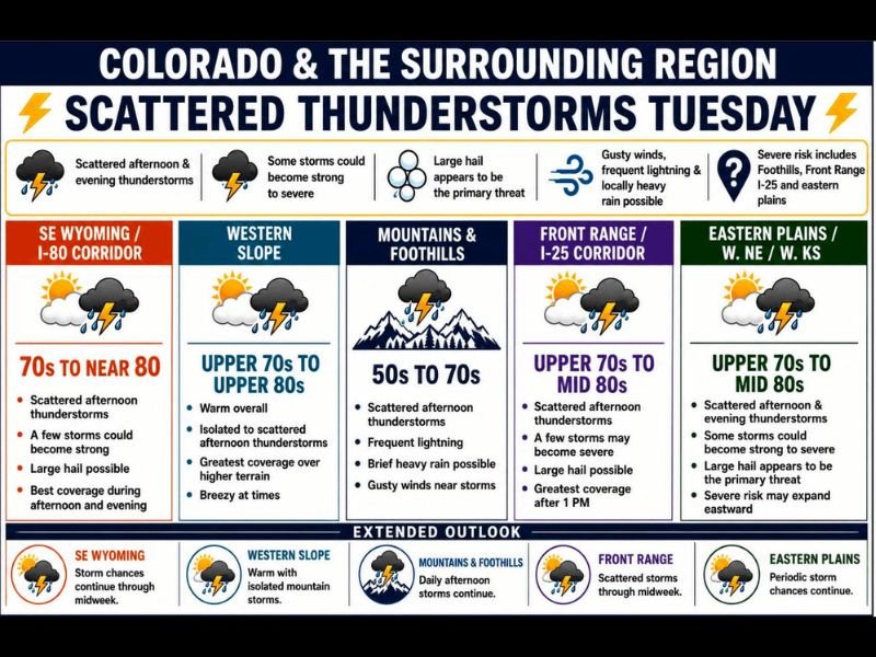
COLORADO — An active stretch of weather continues across Colorado and the surrounding region Tuesday June 2nd, with scattered afternoon and evening thunderstorms expected to develop from the Mountains and Foothills through the Front Range I-25 corridor and eastward into the plains of western Nebraska and western Kansas.
Large hail is the primary threat across multiple zones, with some storms capable of becoming strong to severe particularly along the Front Range and eastern plains. Convective initiation is expected to begin along the Continental Divide and foothills west of I-25 by 1 to 2 PM before storms roll eastward like a conveyor belt through the late afternoon and evening.
Front Range and I-25 Corridor Sees Greatest Severe Risk After 1 PM
The Front Range and I-25 corridor carries the most concentrated severe risk Tuesday, with scattered afternoon thunderstorms expected to develop after 1 PM and a few storms potentially reaching severe limits. Large hail is possible along this zone with temperatures running upper 70s to mid 80s providing sufficient instability for organized storm development. Gusty winds, frequent lightning, and locally heavy rain are all possible with the strongest cells tracking through the Denver metro and surrounding communities.
Large Hail the Primary Threat Across Eastern Plains Into Western Nebraska and Kansas
The eastern plains of Colorado along with western Nebraska and western Kansas sit under an elevated large hail threat Tuesday afternoon and evening, with some storms capable of strengthening significantly as they push into this corridor. Temperatures in the upper 70s to mid 80s across the plains combined with diffluent southwest flow aloft will fuel ongoing storm development through the evening hours. The severe risk across this zone may also expand further eastward as the afternoon progresses.
Storm Coverage Continues Through Midweek Across All Zones
The active pattern is not limited to Tuesday, with storm chances continuing through Wednesday and Thursday across virtually every zone from the mountains through the plains. Daily afternoon mountain and foothills storms will persist through the extended period, while the Front Range and eastern plains will see periodic storm chances continue through midweek. All indications point toward a persistently active and unsettled month of June across Colorado and the surrounding region. Stay with NapervilleLocal.com for the latest weather updates and local forecast coverage.

I’ve lived in Naperville long enough to see how quickly our community changes — from new developments downtown to sudden shifts in our Midwest weather. Reporting on Naperville news and daily forecasts gives me the chance to keep neighbors informed about what really matters. My goal is simple: deliver clear, timely updates so you always know what’s happening in our city and what to expect from the skies above.