
Rare June Cold Front Dropping Morning Lows Into the 50s Across the Southeast Including Georgia Tennessee and the Carolinas With Fall-Like Feel Arriving Thursday Into the Weekend
SOUTHEASTERN UNITED STATES — A rare and welcome June cold front is set to deliver a fall-like feel across a broad swath of the Southeast by Thursday morning, dropping overnight low temperatures into the 50s across Georgia, Tennessee, the Carolinas, and surrounding states as dry air pours in behind the frontal passage.
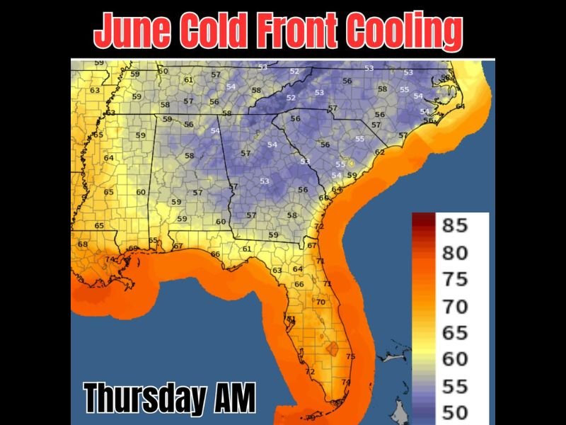
The Thursday morning low temperature map shows deep blue and purple shading blanketing the interior Southeast with values ranging from 52 to 57 degrees across the heart of the region, a striking contrast to the oppressive heat and humidity that dominated earlier this week. The refreshing pattern is expected to persist for a few days heading into the weekend.
Thursday Morning Lows Dropping Into the Low to Mid 50s Across Interior Southeast
The coldest readings Thursday morning are concentrated across the interior Carolinas, central Georgia, and Tennessee, where low temperatures are forecast in the low to mid 50s under the blue and purple shading on the temperature map. Areas further north across Virginia and Kentucky are also expected to see morning lows in the mid to upper 50s, extending the cool and comfortable footprint across a large portion of the eastern United States. These readings represent some of the coolest June morning temperatures this region will see all summer.
Dry Air Accompanying the Front Delivers Genuine Fall-Like Comfort
Beyond the cooler temperatures, the accompanying dry air mass behind the front is what will make this pattern feel truly fall-like across the Southeast. Low humidity combined with temperatures in the 50s for morning lows and pleasant afternoon highs will create conditions rarely experienced in June across this region. Residents are encouraged to open windows, get outside, and enjoy the brief but refreshing break from summer heat and humidity.
Upper Gulf Coast Stays Warmer While Interior Southeast Enjoys the Cooldown
The upper Gulf Coast from Louisiana through the Florida Panhandle will hold onto warmer temperatures in the mid 60s to low 70s Thursday morning, sitting outside the deepest cool air footprint. Florida temperatures remain in the 60s to mid 70s, staying firmly in the warm orange shading well south of the front. The interior Southeast cool snap lasts through the weekend before the summer heat pattern gradually returns. Stay with NapervilleLocal.com for the latest weather updates and local forecast coverage.

I’ve lived in Naperville long enough to see how quickly our community changes — from new developments downtown to sudden shifts in our Midwest weather. Reporting on Naperville news and daily forecasts gives me the chance to keep neighbors informed about what really matters. My goal is simple: deliver clear, timely updates so you always know what’s happening in our city and what to expect from the skies above.