
Alabama Enters Extended Spring-Like Stretch With Upper 60s and Low 70s Before Wet Weekend Brings Widespread Rain
ALABAMA — A spring-like weather pattern is firmly in place across much of Alabama, with today’s highs reaching between 68 and 74 degrees statewide under a mix of sun and clouds. According to the forecast data, this mild trend will continue through much of the week before a wet and soaking weekend system moves into the region.
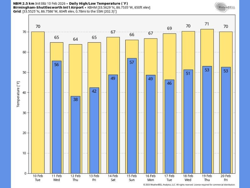
Temperatures are expected to remain well above seasonal averages, offering a prolonged stretch of mild conditions across the state.
Mild Temperatures Dominate the Week
Today’s warmth marks the start of a multi-day stretch of pleasant weather. After a warm afternoon, clouds will thicken this evening, setting the stage for scattered rain late tonight into tomorrow morning.
The primary window for showers is expected from around 10:00 p.m. tonight through 10:00 a.m. tomorrow, with rainfall totals generally one-half inch or less for most areas.
By tomorrow afternoon, some clearing is possible, with highs settling back into the 60s.
Thursday and Friday Remain Dry and Comfortable
The forecast shows Thursday and Friday staying dry and pleasant, with highs generally in the 60s statewide. Some communities in South Alabama may briefly touch 70 degrees, reinforcing the spring-like feel.
Overnight lows during this period range mainly from the upper 30s to upper 50s, depending on location, as shown in the temperature chart.
Wet Weekend Brings Soaking Rainfall
A more dynamic system is expected to impact Alabama over the weekend. Forecast data indicates:
- Widespread rain Saturday night and Sunday
- Rain may begin earlier Saturday in western counties
- Rain totals of 1 to 2 inches likely, with some locations receiving more
Global models suggest the surface low will track through South Alabama, bringing widespread rainfall but limited severe weather potential at this time.
Thunderstorms Possible, Severe Risk Low
While severe storms are not currently expected, the atmosphere will still support a few thunderstorms, especially during the peak rain period. Forecast guidance indicates the air mass will remain relatively stable, keeping the severe threat low.
Temperatures during the weekend are expected to hold in the 60s, even as rain moves through.
Next Week Looks Mostly Dry With Continued Mild Temperatures
Looking ahead, much of next week appears dry, with only isolated showers possible around mid-week on Wednesday. The spring-like pattern continues, with highs in the upper 60s to low 70s, according to the extended outlook.
This consistent temperature trend reflects a broader shift away from winter conditions, with no major cold outbreaks indicated in the near term.
For continued regional weather coverage, pattern analysis, and national climate context, follow updates on NapervilleLocal.com, where weather developments are explained clearly and responsibly.

I’ve lived in Naperville long enough to see how quickly our community changes — from new developments downtown to sudden shifts in our Midwest weather. Reporting on Naperville news and daily forecasts gives me the chance to keep neighbors informed about what really matters. My goal is simple: deliver clear, timely updates so you always know what’s happening in our city and what to expect from the skies above.