Alabama Heads Into Spring-Like Warm Surge With 70s and Even Low 80s Before Weekend Showers and Next Week’s Cooldown
Birmingham, Alabama — A stretch of spring-like warmth is settling across the state this week, with afternoon highs climbing into the upper 60s to mid-70s to start the week and rising even further into the low 80s in parts of Central and South Alabama by Thursday. Temperatures are running about ten degrees above mid-February averages, marking the warmest stretch of 2026 so far.
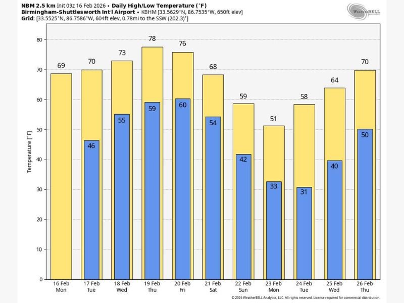
Forecast projections for the Birmingham area show highs steadily rising from the upper 60s early in the week to around 78 degrees by Thursday and 76 degrees Friday. Sunshine will dominate through midweek, providing ideal outdoor conditions before rain chances return later in the week.
Midweek Sunshine With Temperatures Surging Into the 70s
Monday and Tuesday will feature highs around 69 to 70 degrees, followed by 73 degrees Wednesday. By Thursday, much of the state is expected to see highs in the mid-to-upper 70s, with isolated spots in Central and South Alabama possibly touching 80 degrees.
Moisture levels will gradually increase beginning Wednesday and Thursday, bringing a chance for a few widely scattered showers. However, forecasters stress that rainfall should remain light and not widespread. Most areas will continue enjoying highs solidly in the 70s through the end of the workweek.
Even overnight temperatures reflect the warming trend, with lows climbing from the mid-40s early in the week into the upper 50s and near 60 degrees by Thursday morning.
Friday Showers and Uncertainty Into the Weekend
By Friday, a cold front approaching the state will introduce a better chance of showers and possibly an isolated thunderstorm, though no severe weather risk is currently indicated. Highs ahead of the front are still expected to reach the 70s Friday afternoon.
Forecast guidance remains somewhat mixed for Saturday. The American global model (GFS) suggests lingering rain chances, while the European model (ECMWF) favors a drier scenario. For now, the forecast leans toward the drier outcome, but updates are likely as the week progresses. Sunday is expected to be dry with cooler air settling in, as highs dip back into the 60s statewide.
Next Week Brings Cooler Air and Possible Freezing Mornings
Early next week, a stronger push of cooler air will move into the Deep South. Highs are projected to fall into the 50s Monday, with morning lows at or below freezing across the northern half of Alabama on both Monday and Tuesday mornings.
Despite the chill, the cooldown appears temporary. Temperatures are expected to rebound quickly, returning to the 70s by Thursday and Friday (February 26–27). Dry conditions are anticipated for the first half of next week, with rain chances potentially increasing again late in the week.
This rollercoaster pattern underscores Alabama’s late-winter volatility — from near-80-degree warmth to possible freezing mornings within just a few days. For continued coverage of shifting national weather patterns and detailed regional updates, visit NapervilleLocal.com for daily reports and expert analysis.

I’ve lived in Naperville long enough to see how quickly our community changes — from new developments downtown to sudden shifts in our Midwest weather. Reporting on Naperville news and daily forecasts gives me the chance to keep neighbors informed about what really matters. My goal is simple: deliver clear, timely updates so you always know what’s happening in our city and what to expect from the skies above.

