
Heavy Rain, Flooding, and Intense Storm Coverage Soaking the Gulf Coast and Deep South Including Hattiesburg, New Orleans, Jackson, and Mobile on Memorial Day Monday
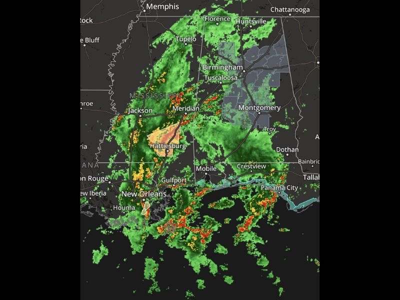
GULF COAST AND DEEP SOUTH — A widespread and intense storm system is hammering the Gulf Coast and Deep South on Memorial Day Monday, May 25, 2026, with heavy rain, flooding, and active radar coverage stretching from New Orleans and Jackson through Hattiesburg, Mobile, Gulfport, and northward through Mississippi toward Memphis and Birmingham. Radar shows the most intense cores concentrated near Hattiesburg with widespread green coverage blanketing virtually the entire region from Louisiana through Alabama and into Tennessee.
Hattiesburg and South Mississippi Bearing the Heaviest Storm Cores Monday
The most intense radar returns on Monday’s storm coverage are concentrated near Hattiesburg, where orange and red signatures indicate the heaviest rainfall rates and most organized storm activity across the entire region. South Mississippi as a whole is saturated with widespread green radar coverage extending from Jackson southward through Meridian and into the Gulf Coast communities.
Communities across south Mississippi including Hattiesburg, Meridian, and Gulfport are experiencing the most significant impacts of the Memorial Day storm system. Flooding and standing water across roadways and low-lying areas is a serious concern across these communities as heavy rainfall continues through the day.
New Orleans Through Mobile and the Gulf Coast Corridor Under Active Storm Coverage
Radar shows widespread and continuous storm coverage pushing across the Gulf Coast corridor from New Orleans and Baton Rouge eastward through Gulfport, Mobile, and toward Panama City and Crestview. The persistent nature of this storm coverage across the coastal zone is creating dangerous conditions for Memorial Day activities along the entire Gulf shoreline.
Flooding is a significant threat across all coastal communities as heavy rain falls on already-saturated ground from prior days of rainfall across the region. Residents and any remaining holiday weekend visitors across the Gulf Coast should avoid flooded roadways and remain indoors while the heaviest storm rounds continue moving through.
Birmingham, Huntsville, and Memphis Corridor Also Seeing Widespread Coverage Monday
The storm coverage extends well north of the immediate Gulf Coast, with widespread green radar signatures pushing through Birmingham, Tuscaloosa, Huntsville, Tupelo, and toward Memphis across the northern portion of the affected zone. A watch or warning area depicted in gray covers portions of eastern Alabama and northwest Georgia, indicating elevated concern for that corridor.
The broad geographic scope of Monday’s storm system means the Memorial Day holiday is being significantly impacted across a large portion of the Deep South and Gulf Coast. Staying weather aware, avoiding flooded roads, and remaining indoors during the heaviest storm activity are the most important safety actions for everyone across the affected region today. Stay with NapervilleLocal.com for the latest weather updates and local forecast coverage.

I’ve lived in Naperville long enough to see how quickly our community changes — from new developments downtown to sudden shifts in our Midwest weather. Reporting on Naperville news and daily forecasts gives me the chance to keep neighbors informed about what really matters. My goal is simple: deliver clear, timely updates so you always know what’s happening in our city and what to expect from the skies above.