
Colorado and Wyoming Brace for 80 MPH Mountain Winds, 60 MPH Plains Gusts, and Snow Over Major Passes as Fire Danger Spikes East of the Divide
COLORADO — A powerful west-to-east jet stream setting up over the Continental Divide is unleashing a multi-day stretch of dangerous wind, mountain snow, and elevated fire danger across Colorado, Wyoming, and parts of Nebraska.
Forecasters warn that the next couple of days will be dominated by intense mountain wave winds, especially at elevations above 7,000 feet.
Mountain Gusts Up to 80 MPH
High-elevation areas in southern Wyoming — including the Medicine Bow Range and Laramie Range — could see wind gusts as high as 80 mph. In Colorado’s central and northern mountains, gusts of 40 to 60 mph are expected through Wednesday, with localized peaks near 70 mph above 7,000 feet.
These powerful winds will not stay confined to the peaks. Portions of the I-25 corridor and the eastern plains could experience gusts of 25 to 40 mph, especially through late afternoon. Nebraska is also included in the zone of stronger plains winds.
By Wednesday, as a cold front moves through, winds will become more widespread, maintaining gusts between 40 and 60 mph across much of the region.
Snow and Difficult Travel in the High Country
Mountain snow is expected to develop Tuesday evening and continue into Thursday morning. The highest snowfall probabilities are forecast along and north of Interstate 70, particularly in the central and northern mountains.
Travel over major passes may become hazardous, including:
- Berthoud Pass
- Cameron Pass
- Rabbit Ears Pass
Resort areas such as Steamboat Springs and Winter Park are likely to pick up a healthy dose of snowfall. Additional accumulations are also expected near Loveland, Arapahoe Basin, Copper Mountain, Keystone, and Breckenridge.
Drivers heading into the high country should prepare for reduced visibility, slick roads, and sudden wind gusts that can make travel treacherous.
Fire Danger and Storm Potential East of the Divide
While snow impacts the mountains, the plains face a different threat. Strong winds combined with dry conditions will elevate fire danger east of the Continental Divide, including across eastern Colorado and into Nebraska.
Rain showers and isolated thunderstorms are possible Tuesday evening ahead of the cold front, with another round possible Wednesday afternoon and evening along and just ahead of the boundary. Despite the storms, gusty winds remain the primary concern.
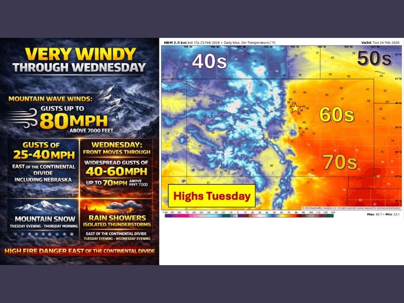
Temperature Contrast Across the Region
Tuesday’s high temperatures show a sharp contrast across the Rockies. Western Colorado and Wyoming remain in the 40s, while eastern Colorado climbs into the 60s, with areas farther east pushing into the 70s ahead of the front. This temperature gradient is helping fuel the strong wind setup.
Conditions are expected to dry out after Wednesday, though forecast models show some uncertainty regarding how the pattern evolves into the weekend and next week.
For travelers or residents monitoring conditions across the Rockies, staying weather-aware over the next 48 hours will be critical. For continued regional weather coverage and updates, keep checking NapervilleLocal.com.

I’ve lived in Naperville long enough to see how quickly our community changes — from new developments downtown to sudden shifts in our Midwest weather. Reporting on Naperville news and daily forecasts gives me the chance to keep neighbors informed about what really matters. My goal is simple: deliver clear, timely updates so you always know what’s happening in our city and what to expect from the skies above.