
Oklahoma Drought Deepens After 95 Days Without Rain in NW Panhandle as Forecast Signals Multi-Day Storm Pattern and Possible Severe Threat
OKLAHOMA — Severe to extreme drought conditions continue to intensify across much of the state, with parts of northwest Oklahoma and the Panhandle now going an alarming 95 days without measurable rainfall.
In Oklahoma City, it has been nine days since even a quarter-inch of rain was recorded. For areas farther northwest, the dry stretch dates back to before Thanksgiving — a troubling sign for a region already vulnerable to wildfire outbreaks.
Fire Danger Rising with Every Wind Event
With parched soils and dormant vegetation, Oklahoma is sitting on what meteorologists describe as “fuel for fires.” Each time winds increase, fire danger escalates quickly.
Although the state is not yet in its peak wildfire season, the prolonged dryness has created conditions more typical of late spring. Grasslands and open areas across western and northern Oklahoma are especially susceptible.
Limited Short-Term Relief
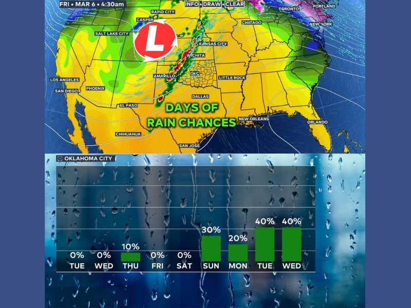
The immediate forecast offers little help. Spotty showers are possible from Wednesday night into Thursday morning, primarily across far northern Oklahoma. However, rain chances remain slim:
- Around a 10% chance of showers in Oklahoma City
- Isolated activity mainly near the Kansas border
- Most areas likely to remain dry
For many communities, this system may provide little more than brief cloud cover.
Pattern Change Signals Better Rain Chances Next Week
Relief may finally be on the horizon. Forecast models show a strong upper-level low lingering to Oklahoma’s west next week. This setup places the state in a more favorable position for repeated rounds of rainfall.
Rain chances are projected to increase steadily:
- Sunday: Around 30%
- Monday: Near 20%
- Tuesday and Wednesday: Around 40% each day
If the pattern unfolds as expected, some parts of Oklahoma could receive at least one inch of rain, with multiple waves of precipitation possible.
There is also a mention of a low-end severe weather threat around the 6th, depending on how the upper system tracks. Details on timing and intensity remain uncertain, but forecasters are closely monitoring the developing setup.
Why This Matters Beyond Oklahoma
While this drought is unfolding far from Illinois, large-scale weather patterns often shift eastward over time. A strengthening storm system in the Plains can eventually influence Midwest conditions, including temperature swings and storm development.
For now, Oklahoma residents continue to wait for meaningful moisture, with growing concern over fire risk and water stress. The coming week could finally bring measurable relief — but until then, drought conditions remain firmly in place.
NapervilleLocal.com will continue tracking major national weather pattern shifts that may influence the Midwest in the days ahead.

I’ve lived in Naperville long enough to see how quickly our community changes — from new developments downtown to sudden shifts in our Midwest weather. Reporting on Naperville news and daily forecasts gives me the chance to keep neighbors informed about what really matters. My goal is simple: deliver clear, timely updates so you always know what’s happening in our city and what to expect from the skies above.