
Strong Cold Front Triggers 40–50 MPH Wind Gusts Across Michigan’s Upper Peninsula and Northern Lake Michigan Shorelines Through Wednesday Morning
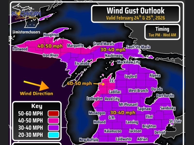
MICHIGAN — A sharp cold front sweeping through the state on February 24th is bringing a noticeable wind shift and widespread gusty conditions, with parts of the Upper Peninsula and northern Lake Michigan shoreline seeing gusts as high as 50 mph.
As the front moves east, winds are shifting from southerly to west and northwest, ushering in stronger gust potential from Tuesday afternoon into early Wednesday morning.
Western Upper Peninsula: Strongest Gusts
The highest wind speeds are forecast across the western Upper Peninsula, including communities near Ironwood, Houghton, and Iron River, where gusts could reach 40 to 50 mph.
Marquette and surrounding areas are also expected to see elevated gusts within that same 40–50 mph range. These winds will be especially noticeable in higher terrain areas and exposed shoreline locations along Lake Superior.
Eastern Upper Peninsula and Northern Lower Michigan
Across the eastern Upper Peninsula — including Grand Marais, Naubinway, and Sault Ste. Marie — gusts are expected to range between 30 and 40 mph.
In northern Lower Michigan, areas such as:
- Traverse City (T.C.)
- Gaylord
- Alpena
- Cadillac
- West Branch
- Oscoda
could see gusts between 40 and 50 mph, particularly closer to Lake Michigan.
Further inland and across central portions of the Lower Peninsula — including Grand Rapids (G.R.), Lansing, Flint, Jackson, Mt. Pleasant, and Saginaw — winds are projected to stay in the 30 to 40 mph range.
Timing: Tuesday Afternoon Through Early Wednesday
The strongest gusts are expected from Tuesday afternoon into early Wednesday morning as the cold front pushes through and pressure gradients tighten behind it.
The wind direction shift to west and northwest will enhance gust potential, especially in areas exposed to open water and elevated terrain.
What to Expect
While these wind speeds are below severe thresholds, they are strong enough to:
- Knock over unsecured outdoor items
- Shift trash bins
- Impact high-profile vehicles
- Create choppy conditions along the Great Lakes
Residents are encouraged to secure loose objects and use caution if traveling, particularly in northern and western Michigan where gusts will be strongest.
Although these winds are occurring outside Illinois, strong frontal systems like this often signal broader pattern changes across the Midwest. NapervilleLocal.com will continue monitoring regional weather systems that may influence Illinois in the days ahead.

I’ve lived in Naperville long enough to see how quickly our community changes — from new developments downtown to sudden shifts in our Midwest weather. Reporting on Naperville news and daily forecasts gives me the chance to keep neighbors informed about what really matters. My goal is simple: deliver clear, timely updates so you always know what’s happening in our city and what to expect from the skies above.