
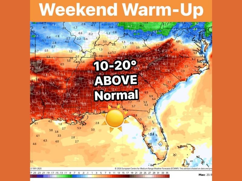
Southeast Set to Surge 10–20 Degrees Above Normal by Sunday as Major Late-February Warm-Up Spreads from Texas to the Carolinas
SOUTHEAST UNITED STATES — After a prolonged stretch of winter chill, a dramatic pattern shift is set to send temperatures soaring 10 to 20 degrees above normal across much of the Southeast by Sunday, marking a significant late-February warm-up.
Forecast data shows widespread positive temperature anomalies stretching from Texas and Louisiana through Mississippi, Alabama, Georgia, Tennessee, and the Carolinas, with the warmest departures centered across the Deep South.
20 Degrees Above Normal in Some Areas
The core of the warmth is expected across:
- Louisiana
- Mississippi
- Alabama
- Georgia
- South Carolina
- North Carolina
In these states, temperatures could run 15 to 20 degrees above average, especially by Sunday. The warm anomaly extends west into eastern Texas and Arkansas, and northeast into parts of Tennessee and Virginia.
Even areas closer to the Mid-Atlantic may see temperatures running 8–12 degrees above normal.
A Sharp Contrast to the North
The temperature map highlights a stark dividing line. While the Southeast warms significantly, cooler-than-normal air remains positioned farther north, including portions of the Midwest and Northeast.
This contrast underscores how quickly the pattern is evolving, with winter loosening its grip across the southern tier of the country.
What This Means for the End of February
For many in the Southeast, the upcoming weekend could feel more like early spring than late February. After recent cold outbreaks, the warmer air mass will provide:
- Milder afternoons
- Reduced frost concerns
- A noticeable improvement in comfort levels
While winter is not officially over, this warm-up signals a transition toward a more active and shifting late-season pattern.
Broader Weather Pattern Implications
Large-scale warm-ups across the southern United States often coincide with stronger storm systems developing across the central part of the country. As warm air pushes northward, it can interact with lingering cold air masses, sometimes increasing the risk of spring-like storm setups in the weeks ahead.
Though this warmth is concentrated well south of Illinois, shifts like this often precede broader national changes in the jet stream pattern. NapervilleLocal.com will continue tracking national weather trends and major temperature swings that could eventually influence conditions here in the Midwest.

I’ve lived in Naperville long enough to see how quickly our community changes — from new developments downtown to sudden shifts in our Midwest weather. Reporting on Naperville news and daily forecasts gives me the chance to keep neighbors informed about what really matters. My goal is simple: deliver clear, timely updates so you always know what’s happening in our city and what to expect from the skies above.