
Slow-Moving Weekend Front Could Soak Florida and the Southeast with Widespread 1-Inch Rainfall as Showers Linger Into Saturday
SOUTHEAST UNITED STATES — A slow-moving frontal boundary is expected to drift into the region this weekend, bringing lingering showers and the potential for widespread rainfall totals near or above one inch — especially across Florida and portions of the Deep South.
Unlike stronger winter fronts that usher in sharp cool-downs, this boundary is forecast to remain relatively flat and slow-moving, allowing rain bands to persist rather than quickly sweep through.
Friday: Rain Expands Across the Gulf Coast and Florida
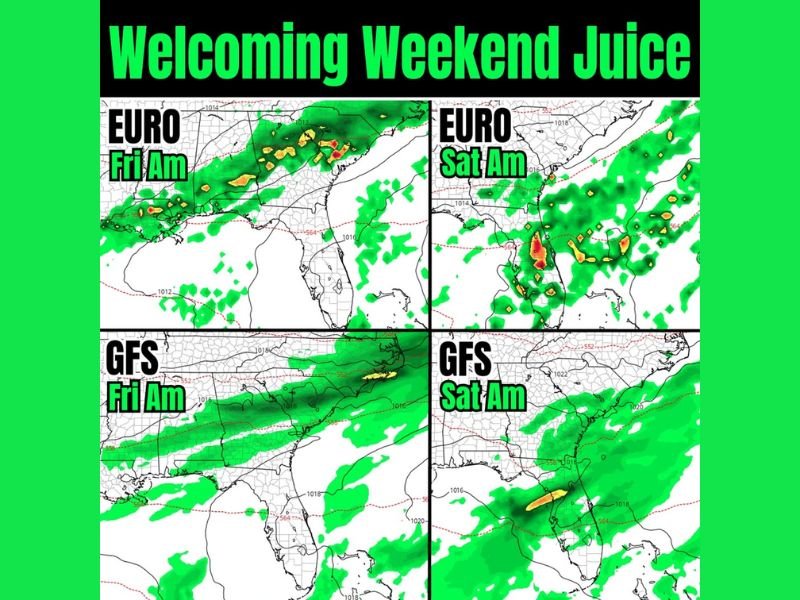
Model guidance from both the European (EURO) and GFS forecast models shows rain developing as early as Friday morning across parts of:
- Louisiana
- Mississippi
- Alabama
- Georgia
- Northern Florida
By Friday morning, scattered showers are expected across the northern Gulf Coast and stretching eastward into Georgia and northern Florida. Florida’s peninsula may see increasing cloud cover with showers building later in the day.
Saturday: Heavier Rain Focused on Florida
By Saturday morning, rainfall coverage becomes more concentrated across Florida, particularly central and northern sections of the state.
Both major models indicate:
- A broad swath of steady rain across much of Florida
- Embedded heavier downpours possible
- Continued showers extending into southern Georgia
The persistence of this system is what raises the potential for meaningful rainfall totals. With the boundary lingering rather than racing offshore, localized areas could exceed one inch, and widespread totals near one inch appear plausible.
Outdoor Plans Could Be Impacted
With rain chances increasing into the weekend, outdoor events and travel plans across Florida and parts of the Southeast may need adjustments.
The lack of a strong cold push means temperatures are not expected to drop dramatically behind the front. Instead, the focus remains on clouds and steady precipitation.
Why This Pattern Matters
A flat frontal boundary combined with moist Gulf air can be an efficient rainfall producer, particularly when upper-level support lingers nearby. While no major severe outbreak is indicated in this setup, pockets of moderate to heavy rain are possible.
NapervilleLocal.com will continue monitoring national weather trends and major systems that may influence Midwest conditions in the days ahead.

I’ve lived in Naperville long enough to see how quickly our community changes — from new developments downtown to sudden shifts in our Midwest weather. Reporting on Naperville news and daily forecasts gives me the chance to keep neighbors informed about what really matters. My goal is simple: deliver clear, timely updates so you always know what’s happening in our city and what to expect from the skies above.