
Midwest and Dixie Alley Enter March Tornado Season Zone as Historical Data Highlights Highest Risk from Texas to Alabama
United States — With meteorological spring set to begin in just days, historical data shows that March marks the early surge of tornado season across the Lower Midwest and the Mid-South, particularly across the region commonly known as Dixie Alley.
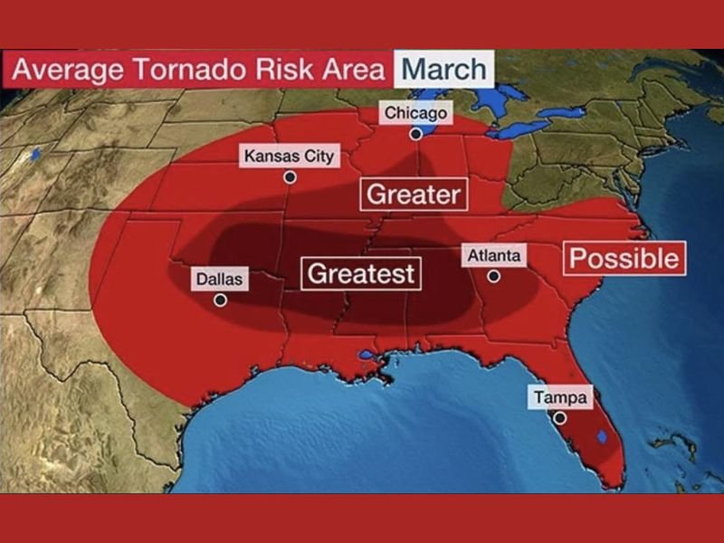
The historical March average tornado risk map highlights a concentrated “Greatest” risk zone stretching from eastern Texas through Louisiana, Arkansas, Mississippi and into western Alabama. Cities such as Dallas, Kansas City and Atlanta sit within or near elevated activity zones, underscoring how widespread early-season severe weather can become during this transitional month .
Where the Highest Historical Risk Exists
The darkest shading on the map — labeled “Greatest” — centers over:
- Eastern Texas
- Louisiana
- Arkansas
- Mississippi
- Western Alabama
This corridor represents the area where tornadoes historically occur most frequently during March. The region is often associated with Dixie Alley, known for fast-moving storm systems, strong wind shear, and higher nighttime tornado risk.
Surrounding that core area is a broader “Greater” risk zone that expands northward into Missouri and parts of the Midwest, and eastward toward Georgia and portions of the Southeast. Even parts of the southern Great Lakes region fall within lighter shading, indicating that tornado activity begins spreading northward as spring advances.
Why March Signals the Start of Tornado Season
March represents a significant atmospheric transition. As warmer Gulf moisture surges northward and collides with lingering winter air masses, the contrast creates conditions favorable for severe thunderstorms.
During early spring:
- The jet stream remains strong
- Temperature contrasts are sharp
- Surface moisture increases
- Storm systems move quickly across the central U.S.
These ingredients combine to support organized severe weather outbreaks. While peak tornado season typically arrives later in April and May for the central Plains and upper Midwest, March historically brings the first major uptick across the South and Lower Midwest.
What This Means Moving Forward
It’s important to note that this map reflects historical averages, not a guaranteed forecast for this year. However, it serves as a seasonal reminder that tornado activity becomes increasingly common during March.
Residents across Texas, Louisiana, Arkansas, Mississippi, Alabama, Missouri, and parts of the Midwest should begin reviewing severe weather safety plans, ensuring alert systems are active, and staying informed as spring storm systems develop.
As meteorological spring begins, the historical pattern is clear: tornado season starts shifting northward, beginning in Dixie Alley and gradually expanding across the central and eastern United States.
For continued seasonal outlooks and severe weather updates across the Midwest and beyond, visit NapervilleLocal.com for detailed coverage.

I’ve lived in Naperville long enough to see how quickly our community changes — from new developments downtown to sudden shifts in our Midwest weather. Reporting on Naperville news and daily forecasts gives me the chance to keep neighbors informed about what really matters. My goal is simple: deliver clear, timely updates so you always know what’s happening in our city and what to expect from the skies above.