
Colorado Front Range Braces for 60 mph Wind Gusts as Snow Intensifies Along I-70 and Fire Danger Rises East of the Divide
Colorado — A powerful midweek weather system is sweeping across the Denver and Front Range region, bringing widespread wind gusts of 40 to 60 mph, continued mountain snowfall, and elevated fire danger east of the Continental Divide.
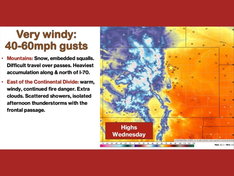
As a cold front pushes from north to south through the state, conditions remain very windy across much of eastern Colorado. Gusts in the 40–60 mph range are expected through the afternoon, creating difficult travel for high-profile vehicles and increasing the risk of blowing debris.
Mountain Snow and Travel Concerns Along I-70
In the mountains, snowfall continues — particularly along and north of Interstate 70, where embedded snow squalls are expected. Forecasters indicate that the heaviest accumulation will favor areas along and north of I-70 above pass level, with a few inches possible even into some mountain valleys, especially near the Highway 40 corridor .
Travel over mountain passes is expected to be difficult at times. Rapidly changing visibility, gusty winds, and bursts of heavier snowfall could create hazardous driving conditions. Motorists planning to cross the higher elevations are urged to prepare for winter travel conditions despite the calendar nearing spring.
The combination of snow and strong winds may also produce localized whiteout conditions in exposed terrain.
Warm, Windy and Elevated Fire Danger East of the Continental Divide
East of the Continental Divide, conditions are markedly different. Downslope winds and compressional heating are helping maintain warmer temperatures across the plains and urban corridor, including Denver and surrounding communities .
Temperatures east of the mountains are forecast to climb into the 60s and 70s, while strong winds persist. This combination raises continued fire danger, especially in dry grassland areas. Officials warn that even small sparks could spread quickly under these conditions.
Additional impacts east of the Divide include:
- Increasing cloud cover during the afternoon
- A few scattered showers
- The possibility of an isolated afternoon thunderstorm as the front passes
While precipitation chances remain limited, gusty winds will continue into Thursday as mountain wave activity fluctuates behind the frontal boundary.
What Comes Next
Beyond this weekend, forecast confidence decreases significantly. Long-range guidance suggests a less defined pattern heading into next week, with no clear signal on whether the region will trend wetter, colder, or return to milder conditions.
For now, the focus remains on managing the immediate impacts: strong winds statewide, heavy mountain snow near I-70, and elevated fire danger across eastern Colorado.
Residents and travelers are encouraged to monitor local advisories, especially for mountain travel routes and fire weather warnings. As the weather pattern evolves, updates will continue to clarify the outlook.
For continued regional weather coverage and detailed updates on significant weather events across the United States, visit NapervilleLocal.com for comprehensive reporting.

I’ve lived in Naperville long enough to see how quickly our community changes — from new developments downtown to sudden shifts in our Midwest weather. Reporting on Naperville news and daily forecasts gives me the chance to keep neighbors informed about what really matters. My goal is simple: deliver clear, timely updates so you always know what’s happening in our city and what to expect from the skies above.