
Alabama Braces for Heavy Rain and Thunderstorms Thursday as Storms Shift from Tuscaloosa and Birmingham South of I-20 by Night
Alabama — Occasional heavy downpours and thunderstorms are expected statewide Thursday as a surge of moisture moves across the region, with the most active weather shifting from north to south through the day.
Forecasters indicate rain chances will increase steadily, with heavier pockets developing during the afternoon and evening hours. While most areas are expected to receive around an inch of rain or less, locally higher totals are possible under stronger storm cells.
Thursday Morning: Light Showers and Cloud Cover
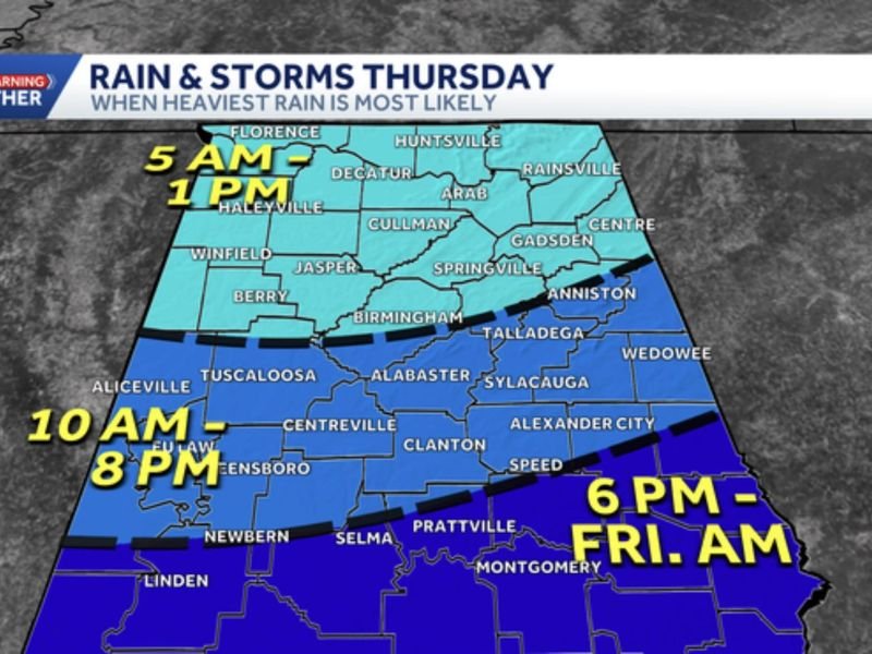
Rain chances begin early Thursday, with partly to mostly cloudy skies and scattered light showers possible across northern and central Alabama. Radar projections show activity increasing between 5 a.m. and 1 p.m., especially across areas near Florence, Huntsville, Decatur, and Gadsden .
These morning showers are expected to be mostly light to moderate, though brief heavier bursts cannot be ruled out.
Thursday Afternoon: Stronger Storms Develop in Central Alabama
By late morning into the afternoon, rain and thunder become more likely across central counties, including Tuscaloosa, Birmingham, Clanton, Talladega, and Centreville .
The heaviest coverage during this phase is projected between approximately 10 a.m. and 8 p.m., with embedded thunderstorms producing locally heavier rainfall. Coverage is expected to expand southward through the evening commute.
Although thunderstorms are possible, severe weather is not currently anticipated. However, some storms could produce brief downpours capable of reducing visibility and creating ponding on roadways.
Thursday Night: Storms Shift South of I-20
As the system progresses, the greatest concentration of heavier storms shifts south of Interstate 20 during the evening and overnight hours .
Between 6 p.m. and midnight — and possibly lingering into early Friday morning — areas near Prattville, Montgomery, Selma, and Alexander City could see locally heavy rainfall.
Rainfall totals across the state are expected to average around an inch or less, though localized higher amounts remain possible where storms repeatedly track over the same area.
What Residents Should Expect
The overall setup points toward a day of on-and-off rain with pockets of heavier downpours rather than a continuous statewide soaking.
Residents should plan for:
- Wet roads during both morning and evening commutes
- Periods of heavier rainfall in central and southern counties
- Occasional thunder but limited severe risk
- Cooler, cloudy conditions for most areas
As the low-pressure system exits overnight, rain coverage should gradually diminish heading into Friday morning.
For continued regional weather coverage and forecast updates from across the country, visit NapervilleLocal.com for detailed analysis and daily reporting.

I’ve lived in Naperville long enough to see how quickly our community changes — from new developments downtown to sudden shifts in our Midwest weather. Reporting on Naperville news and daily forecasts gives me the chance to keep neighbors informed about what really matters. My goal is simple: deliver clear, timely updates so you always know what’s happening in our city and what to expect from the skies above.