
Two Snow Systems to Close February and Open March Across Minnesota, Michigan, Illinois and Ohio With 2–4 Inches Possible
Midwest and Great Lakes — The end of February and start of March are shaping up to feature two fast-moving snow systems across the Upper Midwest and Great Lakes, with the second wave potentially bringing higher totals from Illinois through Ohio.
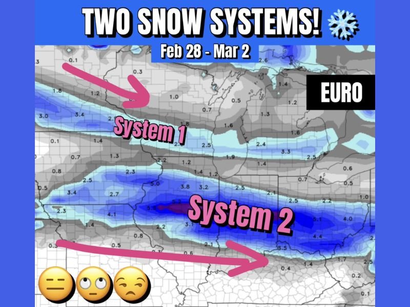
Forecast guidance shows the first system arriving on Saturday, February 28, delivering light snowfall from Minnesota across Wisconsin into Michigan. A second system, expected around March 1–2, could produce more impactful accumulations farther south and east.
System One: Light Snow From Minnesota to Michigan
The first wave is projected to track across the northern tier of the region, spreading lighter snow from Minnesota into Wisconsin and Michigan .
Accumulations with this system appear modest, generally light in nature, with snowfall amounts mostly under a few inches. The band is narrow and progressive, meaning snowfall will likely move through quickly rather than stall over one area.
Travel impacts with System One should remain limited, though brief slick conditions are possible in areas receiving steady snow during peak periods.
System Two: Higher Totals Possible From Illinois Through Ohio
Attention then turns to the second system, arriving March 1–2, which could bring more substantial snowfall from Illinois through Indiana and into Ohio .
Forecast models show a more pronounced band of snowfall stretching west-to-east across central Illinois, southern Indiana, and much of Ohio. Some model projections suggest 2 to 4 inches of snow are certainly possible, particularly within the heavier core of the band.
However, placement of the heaviest totals remains uncertain. The GFS and EURO models differ slightly on exactly where the most concentrated snowfall will occur, meaning small track shifts could change which communities see higher amounts.
Model Differences and Forecast Confidence
While both major forecast models agree that two separate systems will move through the region, they disagree on the precise placement of the heavier snow band associated with the second system.
The European model (EURO) indicates a defined zone of moderate snowfall extending from central Illinois across Indiana into Ohio, while lighter totals remain farther north near the Great Lakes .
This setup suggests the greatest travel impacts may occur during the March 1–2 window, especially if snowfall rates briefly intensify within the main band.
What Residents Should Expect
The bottom line:
- Saturday (Feb 28): Light snow from Minnesota to Michigan
- March 1–2: Potentially higher snowfall from Illinois through Ohio
- 2–4 inches possible in parts of the second system’s core
- Track adjustments could shift the heaviest band north or south
As the calendar turns to March, winter is not finished across the Midwest and Great Lakes. Residents should monitor updated forecasts, particularly for the March 1–2 system, which carries the greater potential for measurable accumulation.
For continued regional weather updates and detailed forecast analysis, visit NapervilleLocal.com for the latest coverage.

I’ve lived in Naperville long enough to see how quickly our community changes — from new developments downtown to sudden shifts in our Midwest weather. Reporting on Naperville news and daily forecasts gives me the chance to keep neighbors informed about what really matters. My goal is simple: deliver clear, timely updates so you always know what’s happening in our city and what to expect from the skies above.