
Powerful 40–60 MPH Mountain Gusts Continue Along Wyoming Divide as Blocking Ridge Breaks Down, Bringing Better Precipitation Chances Into the Rockies
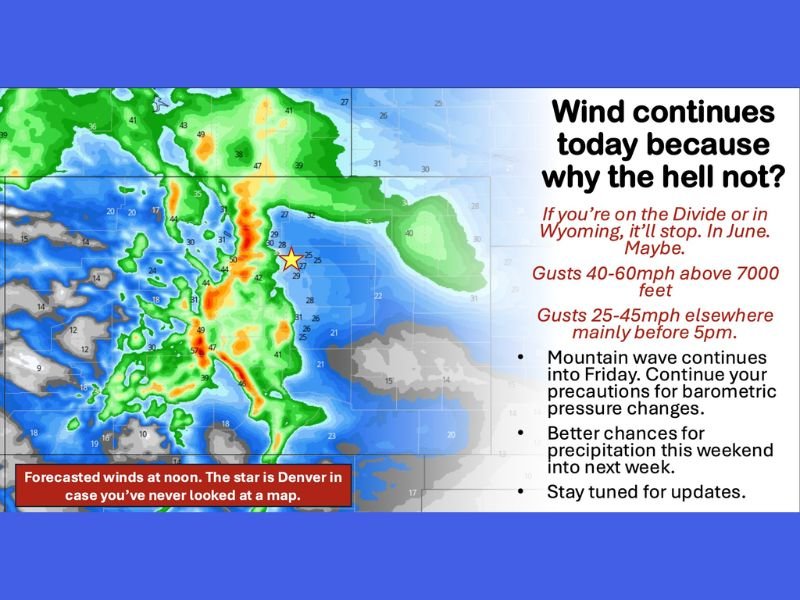
COLORADO & WYOMING — A persistent high-pressure pattern over the Desert Southwest is keeping strong winds locked in across the Rockies, with gusts of 40 to 60 mph above 7,000 feet along the Wyoming Divide continuing through Thursday and into Friday.
Lower elevations across parts of Colorado and Wyoming are also seeing gusty conditions, with 25 to 45 mph winds likely, mainly before 5 p.m. The strongest impacts remain focused in higher terrain areas, where mountain wave activity continues to enhance wind speeds.
High-Pressure Ridge Driving the Wind Pattern
Meteorologists point to a stubborn ridge of high pressure centered over northern Mexico and portions of the Desert Southwest as the driving force behind the ongoing wind pattern. This blocking ridge has forced the storm track to shift north-northwest, limiting storm development over the Four Corners region and keeping the atmosphere moisture-starved.
As a result, no significant storm systems have been able to organize from the Desert Southwest into Colorado or Wyoming. Instead, the pressure gradient between high pressure to the south and lower pressure systems to the north has fueled repeated wind events across the Front Range and mountain communities.
Along the Continental Divide in Wyoming, the wind is expected to remain particularly persistent. Forecast guidance suggests elevated gusts may not ease substantially until later Friday.
Barometric Pressure Changes and Health Impacts
With ongoing wind and pressure fluctuations, residents sensitive to barometric pressure shifts may continue to feel impacts such as headaches or fatigue. Forecasters advise staying hydrated and taking precautions as needed while the pattern remains active.
Mountain wave activity — where strong winds descend the eastern slopes of the Rockies — is expected to continue through Friday, particularly impacting higher elevations and exposed ridgelines.
Pattern Shift Could Bring Precipitation Relief
The good news: long-range model data indicates that the blocking ridge is forecast to begin breaking down over the coming days. That shift in the overall synoptic pattern may finally open the door to better precipitation chances across Colorado and Wyoming this weekend and into next week.
Once the ridge weakens, the storm track could adjust southward, allowing systems to originate closer to the Desert Southwest and Four Corners region — a more favorable setup for meaningful moisture.
While it remains too early to pinpoint exact timing, totals, or impacts, early trends show increasing confidence that a more active and wetter pattern may develop.
What to Expect Next
- 40–60 mph gusts above 7,000 feet along the Wyoming Divide
- 25–45 mph gusts elsewhere, mainly before 5 p.m.
- Mountain wave activity continuing into Friday
- Improving precipitation chances this weekend and next week
For now, windy conditions remain the headline across the Rockies. But if the ridge breakdown unfolds as projected, the region could finally transition toward a more balanced and potentially wetter setup in the days ahead.
Stay with NapervilleLocal.com for continuing weather updates and detailed forecast analysis as the pattern evolves.

I’ve lived in Naperville long enough to see how quickly our community changes — from new developments downtown to sudden shifts in our Midwest weather. Reporting on Naperville news and daily forecasts gives me the chance to keep neighbors informed about what really matters. My goal is simple: deliver clear, timely updates so you always know what’s happening in our city and what to expect from the skies above.