
Increasing Snow Storm Odds Target Washington, Baltimore, Philadelphia and New York Corridor March 2–3 as Thermal Boundary Sets Up Across Mid-Atlantic and Northeast
MID-ATLANTIC & NORTHEAST — The odds of a significant snow storm next week are increasing, according to a new National Weather Service medium-range outlook highlighting a developing system along a sharp cold-warm boundary.
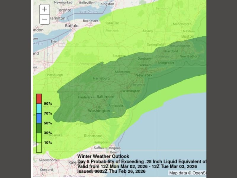
The forecast window covers 12Z Monday, March 2 through 12Z Tuesday, March 3, and shows a growing zone of higher probabilities for impactful winter weather stretching from parts of West Virginia and Maryland through Pennsylvania, New Jersey, and into southern New York and southern New England.
Highest Probabilities Centered Along I-95 Corridor
The outlook map indicates the strongest signal for meaningful precipitation — defined as exceeding 0.25 inch liquid equivalent — across a corridor that includes:
- Washington, D.C.
- Baltimore, Maryland
- Annapolis
- Allentown, Pennsylvania
- Philadelphia
- Wilmington
- New York City
- Bridgeport and Hartford, Connecticut
This darker shaded zone suggests a 50–70% probability of impactful precipitation, with some localized areas trending even higher. Surrounding regions, including Pittsburgh, Scranton, Albany, Boston, and parts of western Virginia, remain in lower but still notable probability zones.
Thermal Gradient Storm Adds Uncertainty
Forecasters describe this as a thermal gradient storm, meaning it will form along a sharp boundary between cold air to the north and warmer air to the south.
Where that boundary ultimately sets up will determine who sees accumulating snow versus a mix or rain. Even small north-south shifts in the storm track could dramatically change snowfall outcomes for major metro areas.
One key concern noted in the discussion is that the storm may trend slightly farther north than currently projected. If that happens, heavier snow bands could shift toward upstate New York and interior New England, reducing totals closer to the southern edge of the corridor.
Timing and Impacts
The current projection focuses on late Monday into early Tuesday (March 2–3). At this range, exact snowfall totals remain uncertain, but the signal for a measurable event continues to strengthen.
Given the population density along the I-95 corridor, even moderate snowfall could disrupt travel, including highways, commuter rail lines, and airports serving Washington, Baltimore, Philadelphia, and New York.
What Happens Next
Forecast confidence is increasing that a system will develop, but critical details remain unresolved:
- Exact placement of the cold-warm boundary
- Northward or southward track adjustments
- Precipitation type transitions
Residents across the Mid-Atlantic and Northeast should closely monitor forecast updates through the weekend, as refinement in model data will clarify the heaviest snow axis.
Stay with NapervilleLocal.com for continued updates as the storm track and thermal setup become clearer in the days ahead.

I’ve lived in Naperville long enough to see how quickly our community changes — from new developments downtown to sudden shifts in our Midwest weather. Reporting on Naperville news and daily forecasts gives me the chance to keep neighbors informed about what really matters. My goal is simple: deliver clear, timely updates so you always know what’s happening in our city and what to expect from the skies above.